

Global Positioning System (GPS) is a United States satellite-based radio navigational, positioning, and time transfer system operated by the Department of Defense (DoD). The system provides highly accurate position and velocity information and precise time on a continuous global basis to an unlimited number of properly-equipped users. The system is
…Category: Navigation
View All Categories
We’ve had a few posts about the Very High Frequency Omnidirectional Range (VOR). Take a look at our introduction and at our CFI’s posts on VOR service volumes and a couple questions that might show up on your exam. Today, we’ll
…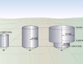
VORs are anything but standard. When operating under the guidance of radio navigational aids like a VOR it’s important to understand the restrictions and standard service volumes (SSV) associated with each aid of intended use. VOR standard service volumes are designated in three classes: Terminal (T), Low Altitude (L), and
…
We’re devoting this week’s posts to the VOR, a radio navigation system used worldwide by private and commercial pilots. This introduction comes from The Student Pilot’s Flight Manual, by William Kershner.
The most useful of the enroute radio navigation aids, other than GPS, is the VHF omnirange,
…
On and around airports, or even driving out in the countryside in an open field, you may see what resembles a giant bowling pin type structure usually surrounded by a security fence. This structure you see is most likely what we in aviation refer to as a VOR. However, not
…
Navigation is the process of piloting an aircraft from one geographic position to another while monitoring one’s position as the flight progresses. It introduces the need for planning, which includes plotting the course on an aeronautical chart, selecting checkpoints, measuring distances, obtaining pertinent weather information, and computing flight time, headings,
…
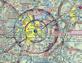
This introduction to aeronautical charts comes from the Pilot’s Handbook of Aeronautical Knowledge, a foundational text for any student pilot.
An aeronautical chart is the road map for a pilot flying under VFR. The chart provides information which allows pilots to track their position and provides
…