On and around airports, or even driving out in the countryside in an open field, you may see what resembles a giant bowling pin type structure usually surrounded by a security fence. This structure you see is most likely what we in aviation refer to as a VOR. However, not always shaped like a bowling pin, VORs come in all forms and sizes, but the role they play in navigation is equally important. Here is an excerpt from the ASA 2015 Private Pilot Test Prep.
The VHF Omnidirectional Range (VOR) is the backbone of the National Airway System, and this radio aid to navigation (NAVAID) provides guidance to pilots operating under visual flight rules as well as those flying instruments.
On sectional aeronautical charts, VOR locations are shown by blue symbols centered in a blue compass rose which is oriented to Magnetic North. A blue identification box adjacent to the VOR symbol lists the name and frequency of the facility, its three-letter identifier and Morse Code equivalent, and other information as appropriate. For example: a small solid blue square in the bottom right hand corner indicates Hazardous Inflight Weather Advisory Service (HIWAS) are available. See the “Radio Aids to Navigation and Communications Box” information in FAA Legend 1.
Some VORs have a voice identification alternating with the Morse Code identifier. Absence of the identifier indicates the facility is unreliable or undergoing routine maintenance; in either case, it should not be used for navigation. Some VORs also transmit a T-E-S-T code when undergoing maintenance.
The VOR station continuously transmits navigation signals, providing 360 magnetic courses to or radials from the station. Courses are TO the station and radials are FROM the station.
TACAN, a military system which provides directional guidance, also informs the pilot of the aircraft’s distance from the TACAN Station. When a VOR and a TACAN are co-located, the facility is called a VORTAC. Civil pilots may receive both azimuth and distance information from a VORTAC.
At some VOR sites, additional equipment has been installed to provide pilots with distance information. Such an installation is termed a VOR/DME (for “distance measuring equipment”).
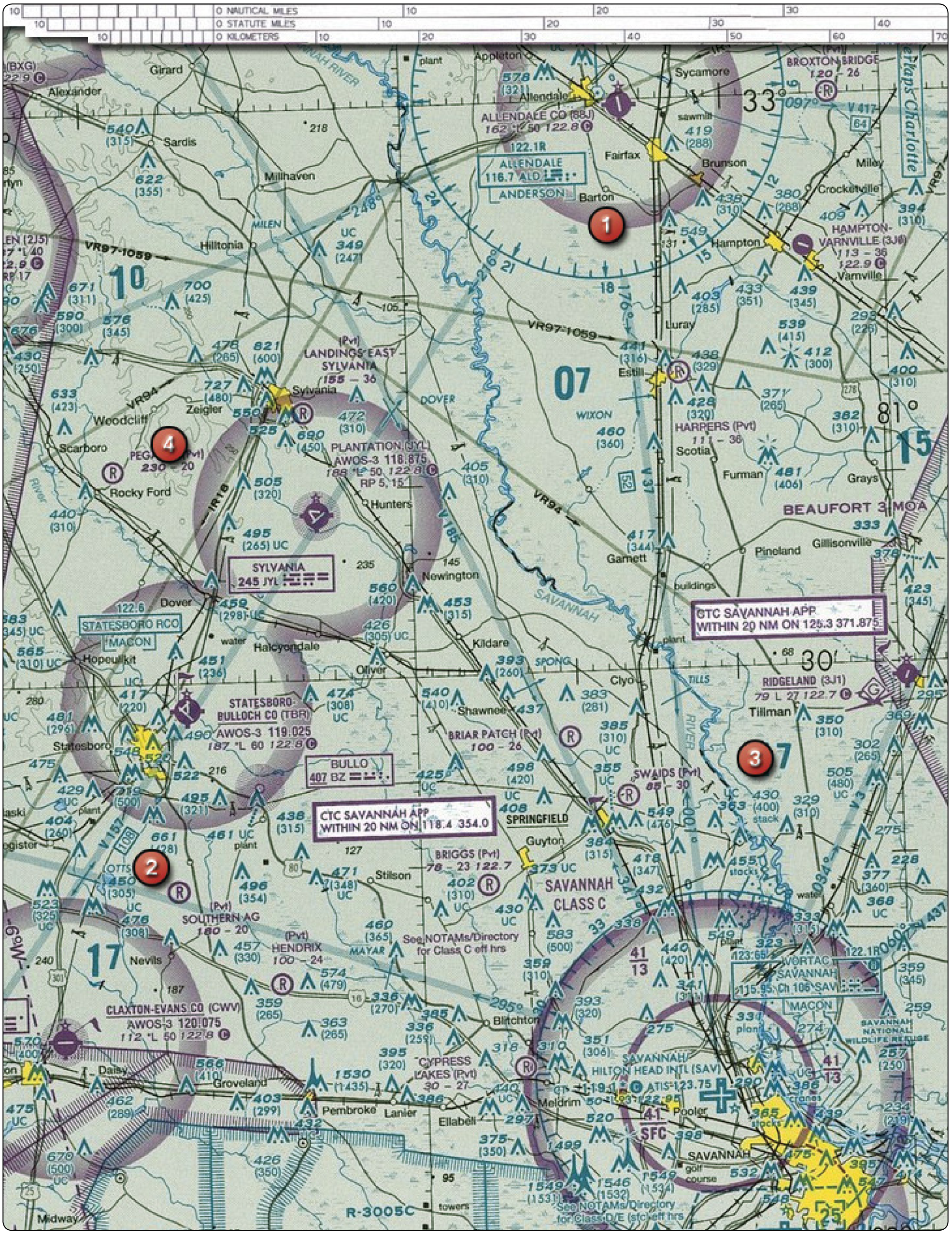
1. (Refer to the figure above.) On what course should the VOR receiver (OBS) be set to navigate direct from Hampton Varnville Airport (area 1) to Savannah VORTAC (area 3)?
A—003°.
B—195°.
C—200°.
2. (Refer to the figure above.) What is the approximate position of the aircraft if the VOR receivers indicate the 320° radial of Savannah VORTAC (area 3) and the 184° radial of Allendale VOR (area 1)?
A—Southeast of Guyton.
B—Town of Springfield.
C—3 miles east of Marlow.