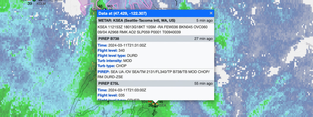
Some of the most important jargon you’ll learn as a pilot has to be how to read a METAR. These “aviation routine weather reports” provide pilots with an accurate depiction of current weather conditions at an airport. METARs are issued on a regularly scheduled basis, usually close to the top of the hour, unless significant weather changes have occurred between routine reports, causing a special METAR, or SPECI, to be issued. METARs use a standard international format (which may as well be called an encryption) that this post will help you decipher.
First of all, METAR as an abbreviation is vague at best. Different sources will tell you this comes from METeorological Aerodrome Report, Meteorological Terminal Aviation Routine Weather Report, Meteorological Terminal Air Report, or Meteorological Airfield Report. Let’s stick with aviation routine weather report and get straight into the decrypting.
Here’s an example of a routine METAR report for a station location:
METAR KGGG 161753Z AUTO 14021G26KT 3/4SM +TSRA BR BKN008 OVC012CB 18/17 A2970 RMK PRESFR
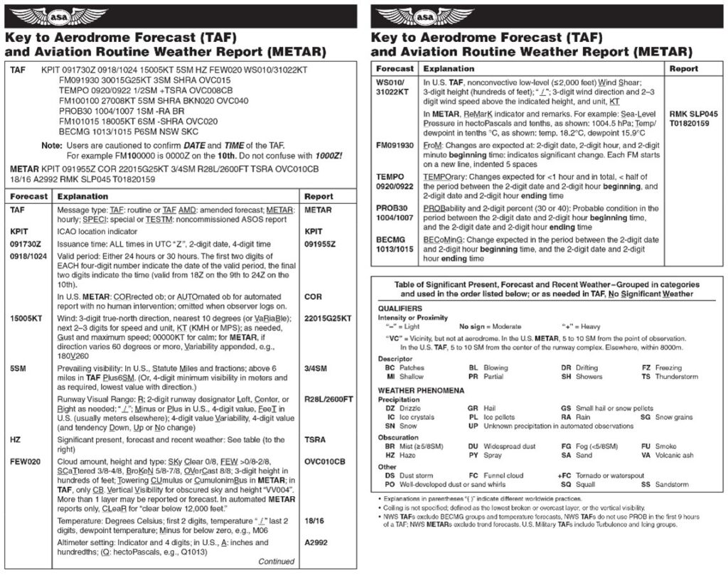
Each METAR contains specific information in sequential order. Let’s go through each bit of the standard formatted coding.
1. METARs begin with the type of report (shown in red).
METAR KGGG 161753Z AUTO 14021G26KT 3/4SM +TSRA BR BKN008 OVC012CB 18/17 A2970 RMK PRESFR]
You will see two types of METAR reports. The routine METAR report, transmitted at a regular time interval, or the aviation selected SPECI, a special report that can be given at any time to update the METAR for rapidly changing weather conditions, aircraft mishaps, or other critical information.
2. Next is the station identifier. A four-letter code as established by the International Civil Aviation Organization (ICAO).
METAR KGGG 161753Z AUTO 14021G26KT 3/4SM +TSRA BR BKN008 OVC012CB 18/17 A2970 RMK PRESFR
In the 48 contiguous states, a unique three-letter identifier is preceded by the letter “K.” For example, Gregg County Airport in Longview, Texas, is identified by the letters “KGGG,” with K as the country designation and GGG as the airport identifier. In other regions of the world, including Alaska and Hawaii, the first two letters of the four-letter ICAO identifier indicate the region, country, or state. Alaska identifiers always begin with the letters “PA,” and Hawaii identifiers always begin with the letters “PH.” Station identifiers can be found on various websites, such as the Aviation Weather Center or NOAA’s METAR Observation Station Identifiers.
3. The third grouping is the date and time of the report. Depicted in a six-digit group (161753Z). The first two digits are the date. The last four digits are the time of the METAR/SPECI, which is always given in coordinated universal time (UTC). A “Z” is appended to the end of the time to denote the time is given in Zulu time (UTC) as opposed to local time. This METAR was issued on the 16th at 1753 Zulu.
METAR KGGG 161753Z AUTO 14021G26KT 3/4SM +TSRA BR BKN008 OVC012CB 18/17 A2970 RMK PRESFR
4. The modifier denotes whether the METAR/SPECI came from an automated source or if the report was corrected.
METAR KGGG 161753Z AUTO 14021G26KT 3/4SM +TSRA BR BKN008 OVC012CB 18/17 A2970 RMK PRESFR
If the notation “AUTO” is listed in the METAR/SPECI, the report came from an automated source. It also lists “AO1” (for no precipitation discriminator) or “AO2” (with precipitation discriminator) in the “Remarks” section to indicate the type of precipitation sensors employed at the automated station. When the modifier “COR” is used, it identifies a corrected report sent out to replace an earlier report that contained an error. If this example had been corrected, the word AUTO would be replaced with COR.
5. The wind is reported with five digits (14021) unless the speed is greater than 99 knots, in which case the wind is reported with six digits. The first three digits indicate the direction the true wind is blowing from in tens of degrees. If the wind is variable, it is reported as “VRB.” The last two digits indicate the speed of the wind in knots (KT) unless the wind is greater than 99 knots, in which case it is indicated by three digits. If the winds are gusting, the letter “G” follows the wind speed. After the letter “G,” the peak gust recorded is provided (G26KT). If the wind direction varies more than 60° and the wind speed is greater than six knots, a separate group of numbers, separated by a “V,” will indicate the extremes of the wind directions.
METAR KGGG 161753Z AUTO 14021G26KT 3/4SM +TSRA BR BKN008 OVC012CB 18/17 A2970 RMK PRESFR
Without gusts, this METAR would include only 14021KT.
6. The prevailing visibility is reported in statute miles as denoted by the letters “SM.” It is reported in both miles and fractions of miles (¾ SM).
METAR KGGG 161753Z AUTO 14021G26KT 3/4SM +TSRA BR BKN008 OVC012CB 18/17 A2970 RMK PRESFR
The runway visual range (RVR) may be reported following the prevailing visibility. RVR is the distance a pilot can see down the runway in a moving aircraft. When RVR is reported, it is shown with an R, then the runway number followed by a slash (/), then the visual range in feet. For example, when the RVR is reported as R17L/1400FT, it translates to a visual range of 1,400 feet on runway 17 left.
7. Now we get to the weather. It can be broken down into two different categories: the qualifiers (+TSRA) and the weather phenomenon (BR).
METAR KGGG 161753Z AUTO 14021G26KT 3/4SM +TSRA BR BKN008 OVC012CB 18/17 A2970 RMK PRESFR
First, the qualifiers of intensity, proximity, and the descriptor of the weather are given. The intensity may be light (–), moderate ( ), or heavy (+). Proximity only depicts weather phenomena that are in the airport vicinity. The notation “VC” indicates a specific weather phenomenon is in the vicinity of 5–10 miles from the airport. Descriptors are used to describe certain types of precipitation and obscurations. Weather phenomena may be reported as being precipitation, obscurations, or other phenomena, such as squalls or funnel clouds. Descriptions of weather phenomena, when they begin or end, and hailstone size are also listed in the “Remarks” sections of the report. The coding for qualifier and weather phenomena are shown in this chart. The weather groups are constructed by considering columns 1–5 in this table sequence: intensity, followed by descriptor, followed by weather phenomena.
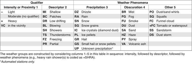
The notation +TSRA BR is “heavy thunderstorms and rain with mist.” Another example, “heavy rain showers” is coded as +SHRA.
8. Next we have the sky condition. This is always reported in the sequence: amount, height, and type or indefinite ceiling/height (vertical visibility).
METAR KGGG 161753Z AUTO 14021G26KT 3/4SM +TSRA BR BKN008 OVC012CB 18/17 A2970 RMK PRESFR
The heights of the cloud bases are reported with a three-digit number in hundreds of feet AGL. Clouds above 12,000 feet are not detected or reported by an automated station. The types of clouds, specifically towering cumulus (TCU) or cumulonimbus (CB) clouds, are reported with their height. The amount of cloud coverage and obscuring phenomena is described using fractions, then reported based on the amount of sky coverage in eighths of the sky from horizon to horizon.
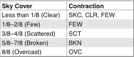
Less than 1/8 is abbreviated as Sky Clear, Clear, or Few; 1/8–2/8 as Few; 3/8–4/8, Scattered; 5/8–7/8, Broken; and 8/8, Overcast. For aviation purposes, the ceiling is the lowest broken or overcast layer, or vertical visibility into an obscuration.
9. The air temperature and dew point are always given in degrees Celsius (C).
METAR KGGG 161753Z AUTO 14021G26KT 3/4SM +TSRA BR BKN008 OVC012CB 18/17 A2970 RMK PRESFR
Temperatures below 0 °C are preceded by the letter “M” to indicate minus.
10. The altimeter setting is reported as inches of mercury (inHg) in a four-digit number group.
METAR KGGG 161753Z AUTO 14021G26KT 3/4SM +TSRA BR BKN008 OVC012CB 18/17 A2970 RMK PRESFR
It is always preceded by the letter “A.” Rising or falling pressure may also be denoted in the “Remarks” sections as “PRESRR” (rising) or “PRESFR” (falling).
11. Lastly, we have the remarks section, which always begins with the letters “RMK.”
METAR KGGG 161753Z AUTO 14021G26KT 3/4SM +TSRA BR BKN008 OVC012CB 18/17 A2970 RMK PRESFR
Comments may or may not appear in this section of the METAR. The information contained in this section may include wind data, variable visibility, beginning and ending times of phenomenon, pressure information, and various other information deemed necessary. An example of a remark regarding weather phenomenon that does not fit in any other category would be: OCNL LTGICCG. This translates as occasional lightning in the clouds and from cloud to ground. Automated stations also use the remarks section to indicate the equipment needs maintenance.
Our sample METAR would be read as follows:
Routine METAR for Gregg County Airport for the 16th day of the month at 1753 zulu from an automated source. Winds are 140 at 21 knots gusting to 26 knots. Visibility is ¾ statute mile. Thunderstorms with heavy rain and mist. Ceiling is broken at 800 feet, overcast at 1,200 feet with cumulonimbus clouds. Temperature 18 °C and dew point 17 °C. Barometric pressure is 29.70 inHg and falling rapidly.
A few more examples:
To find more examples and learn even more about weather events that can affect flying, check out the Aviation Weather Handbook, available at asa2fly.com.


