Chapter 26, “En Route Navigation,” of the new fourth edition of The Pilot’s Manual: Ground School focuses on how to go about the business being an effective pilot/navigator with minimum interruption of safely flying the airplane. The components of successful pilot/navigation are:
- flight planning;
- chart-reading (also known as pilotage) which means determining your position over the ground by comparing the ground features with those marked on the chart;
- using navigation aids to assist and confirm your map-reading;
- making corrections to your flight path over the ground so as to regain your planned course and reach your destination; and
- using dead reckoning to back up your other visual navigation methods.
Today, we’ll feature an excerpt from this chapter specifically on chart-reading in flight. Ground School is available in hardcover and in multiple eBook formats.
Chart-Reading in Flight
The success of map-reading depends on four basic factors:
- a knowledge of direction;
- a knowledge of distance;
- a knowledge of groundspeed; and
- the selection and identification of landmarks and checkpoints.
Select good checkpoint features. Landmarks and checkpoints that can be easily identified, and which will be within your range of visibility when you pass by them, are best. Just how conspicuous a particular feature may be from the air depends on:
- the flight visibility;
- the dimensions of the feature;
- the relationship of your selected feature to other features; the angle of observation;
- the plan outline of the feature if you are flying high; and
- the elevation and side appearance of the feature if you are flying low.
Preferably the feature should be unique in that vicinity so that it cannot be confused with another nearby similar feature. A feature that is long in one dimension and quite sharply defined in another is often useful, because:
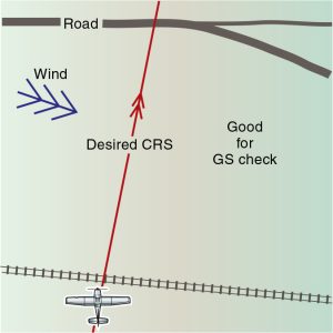
- if a long feature (such as a railroad, canal or road) runs parallel to your planned course, it can assist in maintaining accurate tracking; and
- if a long feature crosses the course it can be used as a position line to aid in determining an updated groundspeed (GS).
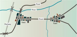
The relationship between your selected feature and other nearby ground features is very important for a positive confirmation of your position. For example, there may be two small towns near each other, but you have chosen as a feature the one that has a single-track railroad to the west of the town and with a road that crosses a river on the north side of the town, whereas the other town has none of these features. This should make positive identification fairly easy.