This week’s focus on the blog is aeronautical charts, specifically charts designed for VFR pilots. An overview of the Terminal, Sectional, and World Aeronautical charts was given in Mondays post and can be found here. Each one of these charts provides a wealth of aeronautical information on airports, airways, airspace, special use airspace, and even terrain. However what I would like to focus on today is how to identify a geographic coordinate using one of these aforementioned VFR charts. To do this we first need to understand the lines of longitude and latitude that are depicted on the chart.
To identify a point on the surface of the earth, a geographic coordinate, or “grid” system was devised. By reference to meridians of longitude and parallels of latitude, any position may be accurately located when using the grid system.
Equidistant from the poles is an imaginary circle called the equator. The lines running east and west, parallel to the equator are called parallels of latitude, and are used to measure angular distance north or south of the equator. From the equator to either pole is 90°, with 0° being at the equator; while 90° north latitude describes the location of the North Pole.

Lines called meridians of longitude are drawn from pole to pole at right angles to the equator. The prime meridian, used as the zero degree line, passes through Greenwich, England. From this line, measurements are made in degrees both easterly and westerly up to 180°.
Any specific geographical point can be located by reference to its longitude and latitude. For example, Washington, DC is approximately 39° north of the equator and 77° west of the prime meridian and would be stated as 39°N 77°W. Note that latitude is stated first.
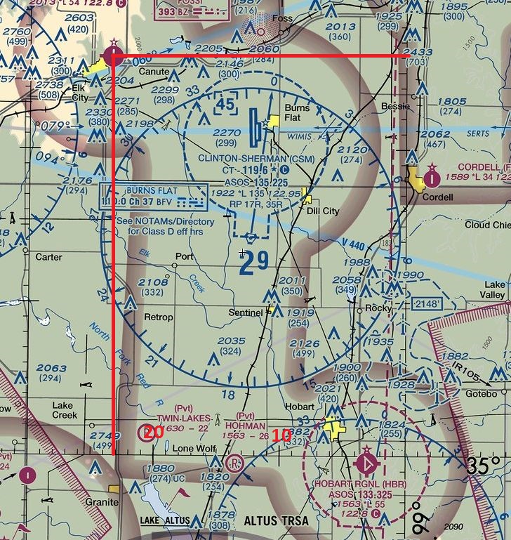
In order to describe a location more precisely, each degree (°) is subdivided into 60 minutes (‘) and each minute further divided into 60 seconds (“), although seconds are not shown. Thus, the location of the airport at Elk City, Oklahoma is described as being at 35°25’55″N 99°23’15″W (35 degrees, 25 minutes, 55 seconds north latitude; 99 degrees, 23 minutes, 15 seconds west longitude). Degrees of west longitude increase from east to west. Degrees of north latitude increase from south to north.
In the figure below you will see Elk City airport, notice in the bottom right corner the numbers 35 and 99 which depict the latitude and longitude. Beginning with the latitude of 35° North count the tick marks up until you reach Elk City airport at about 26. Remember each tick mark represents 1 minute, so our latitude is 35° (degrees) 26’ (minutes) North. You will do the same for longitude; note that as you move right to left your lines of longitude will be increasing. By the time you get to Elk City airport you will have counted 23 tick marks representing 23 minutes. Therefor the longitude is 99° (degrees) 23’ (minutes) W. Remember the VFR charts do not depict seconds so it’s best to round off to the closest minute mark.