Today, we’re featuring an excerpt from Bob Gardner’s The Complete Private Pilot.
A weather front exists where air masses with different properties meet. The terms “warm” and “cold” are relative: 30°F air is warmer than 10°F air, but that “warm” air doesn’t call for bathing suits. Cold air is more dense than warm air, so where two dissimilar masses meet, the cold air stays near the surface. Figure 1 shows a cold front: cold air advancing from west to east and displacing warm air. Because the cold air is dense and relatively heavy, it moves rapidly across the surface, pushing the warm air up. Notice that in both cases the warm air is forced aloft and the cold air stays at the surface. When air is lifted, stuff happens. Just how bad that “stuff” might be is determined by the moisture content of the warm air and where that moisture is coming from.
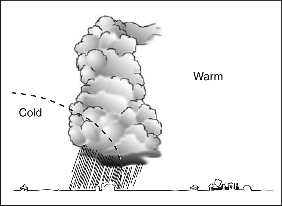
Friction slows the cold air movement at the surface, so that the front is quite vertical in cross-section and the band of frontal weather is narrow. Cold fronts can move as fast as 30 knots. Your awareness of this rapid movement, together with facts you already know about temperature and dew point will allow you to make the following generalizations about cold front weather.
Visibility: Good behind the front. Warm air and pollutants rise rapidly because warm air is less dense than cold air.
Flight conditions: Bumpy as thermal currents rise.
Precipitation: Showery in the frontal area as the warm air is forced aloft and its moisture condenses. The ability of the air to hold moisture decreases as the air cools, and as the moisture contained in each column of rising air condenses into water droplets, showers result.
Cloud type: Cumulus, due to air being raised rapidly to the condensation level. Cumulus clouds are a sign of unstable air; the rising air columns are warmer than the surrounding air and continue to rise under their own power.
Icing possibility: Clear ice. Cumulus clouds develop large water droplets which freeze into clear sheets of ice when they strike an airplane.
A warm front exists when a warm air mass overtakes a slow-moving cold air mass; the lighter warm air cannot displace the heavier cold air, and the warm air is forced to rise as it moves forward (Figure 2). This slow upward movement combined with the slow forward movement characteristic of warm fronts allows the warm air to cool slowly. As it reaches the condensation level, stratiform clouds develop. While cold frontal conditions exist over a very short distance, warm fronts slope upward for many miles, and warm frontal weather may be extensive.
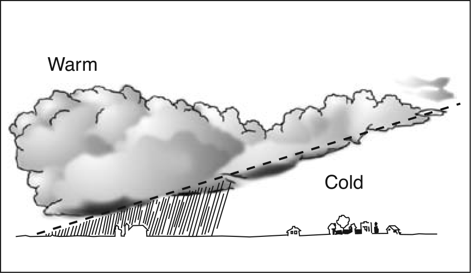
You may encounter warm front clouds 50 to 100 miles from where the front is depicted on the surface analysis chart. The following are the characteristics of warm frontal weather:
Visibility: Poor; pollutants trapped by warm air aloft. Air warmed at the surface can only rise until it reaches air at its own temperature.
Flight conditions: Smooth, no thermal activity.
Precipitation: Drizzle or continuous rain as moist air is slowly raised to the condensation level.
Cloud type: Stratus or layered, the result of slow cooling.
Icing possibility: Rime ice; small water droplets freeze instantly upon contact with an airplane and form a rough, milky coating.
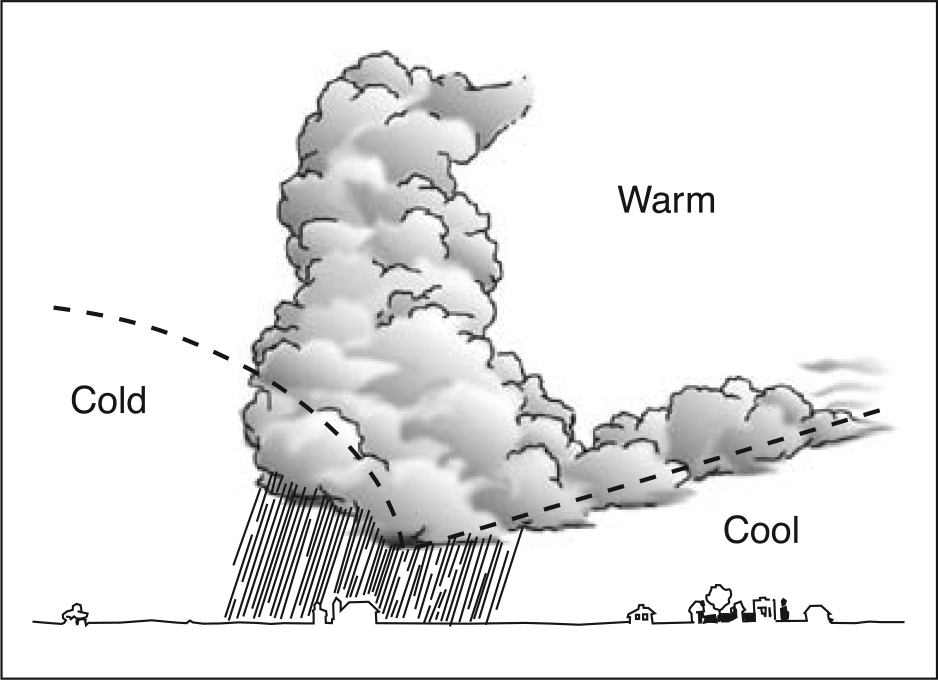
Occasionally, a fast-moving cold front will overtake a warm front (Figure 3) and lift the warm air away from the surface. This is called an occlusion, and occluded frontal weather contains the worst features of both warm and cold fronts: turbulent flying conditions, showers and/or continuous precipitation, poor visibility in precipitation, and broad geographic extent of frontal weather conditions.
Air masses can maintain their warm/cold identity and yet not exert any displacement force. When this happens, the front becomes stationary, and the associated weather covers a large geographic area. In your planning, what you see is probably what you will get during the flight.
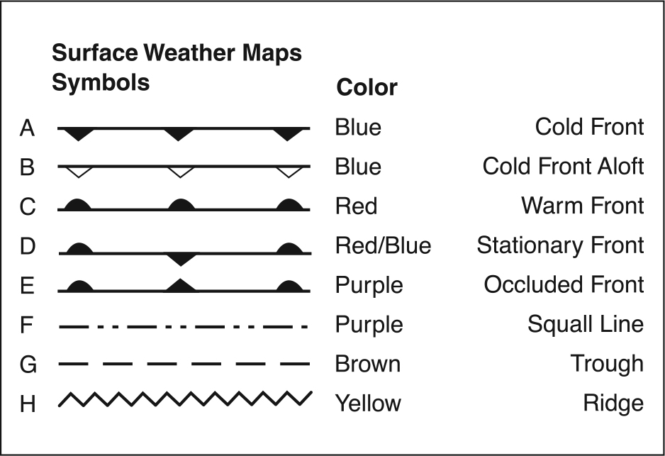
When you look at a weather map which shows frontal positions, cold fronts will be marked in blue, warm fronts in red, occluded fronts will be purple, and stationary fronts will alternate red and blue. You can identify fronts on black-and-white charts because the cold front symbols look like icicles and warm front symbols appear as blisters (Figure 4). Visualize the lifting process, and you will be on your way to being your own weather forecaster.
In flight, when you fly through a front you will notice a change in outside air temperature and wind direction; you will change heading to the right in order to stay on course.
Occluded fronts show both icicles and blisters on the same side of the front in the direction of movement, and stationary fronts show the symbols on opposite sides of the frontal line, indicating opposing forces.
Featured image by Tobias Hämmer from Pixabay.