
As we’ve talked about before, being aware of the weather at takeoff, at your destination, and en route is a key part of flight planning and flying safety. By now you know which models to check before you leave, but an understanding of the basic elements of weather and atmosphere can help you anticipate changes in the weather and in turn make you a better aviator. Today we’ll cover dew point. Here’s how Bob Gardner explains it in the twelfth edition of his textbook The Complete Private Pilot.
To understand and anticipate weather changes, you must be aware of pressure systems and their movement. To know what might happen with cloud formations and obstructions to visibility you must consider the moisture content of the air. All air contains moisture in the form of water vapor; the amount of water a given volume of air can hold is dependent on the temperature of the air. As a volume of air is heated, the amount of moisture it can hold in invisible form increases: a temperature increase of 20°F (11°C) doubles the air’s capacity to hold moisture. Conversely, cooling the air reduces the amount of water vapor that can be hidden from sight. When the air contains 100% of the moisture it can hold invisibly, the moisture becomes visible in the form of clouds, fog, or precipitation. The moisture condenses into droplets which can be seen, and which restrict your ability to see.
Moisture can be added to the atmosphere through evaporation or sublimation. Evaporation can be from a body of water, a field of snow, or from rainfall; sublimation occurs when water changes state from solid to vapor without a liquid phase. In your future, when you are instrument rated and pick up a trace of ice in a cloud, you will see it slowly disappear even though the outside temperature is below freezing…this is an example of sublimation.
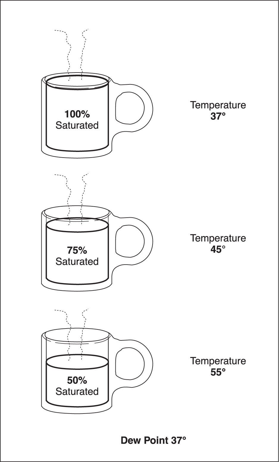
The temperature at which the air becomes saturated and can contain no more moisture, without that moisture getting you wet, is called the dew point. You have heard the television weather person report “The temperature is 65°, the dew point is 48°”—under those conditions, if the air suddenly cools 17° it will be saturated, and any further cooling or addition of moisture to the air will result in fog or rain. What the weather reporter calls relative humidity is simply how close the air is to being saturated. The illustration below uses a cup of liquid (representing the atmosphere) at different temperatures to show how the percentage of moisture content increases from 50% to 100%. A good example of high relative humidity is a hot July day when the air is full of moisture but there isn’t a cloud in the sky. You feel uncomfortable because perspiration on your body cannot evaporate into air already full of moisture. Take a cold can out of a soft drink dispenser on a clear July day and watch beads of water form on its sides. Where do you think that water comes from?
The measure of relative humidity is the spread between temperature and dew point. If that spread is reported to be less than 5°F, you should investigate further to determine the potential for a reduction in visibility. Is the sun rising, or setting? The answer can help you predict the temperature trend and whether the temperature/dew point spread will increase or decrease. Is the wind blowing from over water or from over land? Moisture can be added to the air by evaporation from rain or bodies of water. Moisture being added to the air can tip the balance toward saturation. If your investigation shows the potential for a decrease in the difference between temperature and dew point for any reason, you must consider the possibility that you will not be able to complete the trip under visual conditions.
Knowledge of the temperature/dew point relationship is valuable in estimating the height of cloud bases. When rising air currents are evidenced by the formation of cumulus clouds, the air is cooling at the rate of approximately 4.4°F per 1,000 feet. For example, if the temperature at the surface is 78°F and the dew point is 62°F, the difference is 16° ÷ 4.4 x 1,000 = 3,600 feet above the surface. This is where you would expect cloud bases to be, under the conditions stated. For height of cloud bases above sea level, you must add the elevation of the station at which the observations were made.


