[Update: In December 2022, the FAA published the Aviation Weather Handbook (FAA-H-8083-28) which replaced Aviation Weather (AC 00-6) and Aviation Weather Services (AC 00-45).]
Differences in temperature create differences in pressure. These pressure differences drives a complex system of winds in a never ending attempt to reach equilibrium. Wind also transports water vapor and spreads fog, clouds, and precipitation. This week, we have a post from the classic FAA text Aviation Weather (AC 00-6) to describe how the atmosphere circulates around our globe.
Convection
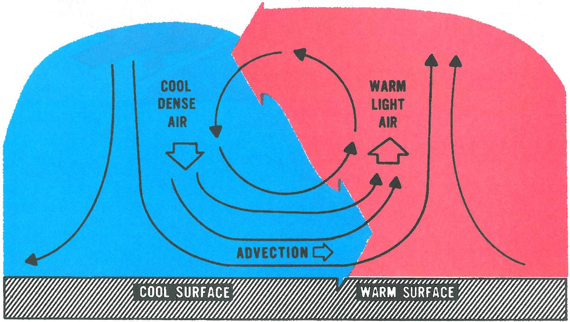
When two surfaces are heated unequally, they heat the overyling air unevenly. The warmer air expands and becomes lighter or less dense than the cool air. The more dense, cool air is drawn to the ground by its greater gravitational force lifting or forcing the warm air upward much as oil is forced to the top of water when the two are mixed. Figure 1 shows the convective process. The rising air spreads and cools, eventually descending to complete the convective circulation. As long as the uneven heating persists, convection maintains a continuous “convective current.”
The horizontal air flow in a convective current is “wind.” Convection of both large and small scales accounts for systems ranging from hemispheric circulations down to local eddies. This horizontal flow, wind, is sometimes called “advection.” However, the term “advection” more commonly applies to the transport of atmospheric properties by the wind, i.e., warm advection; cold advection; advection of water vapor, etc.
Pressure Gradient Force
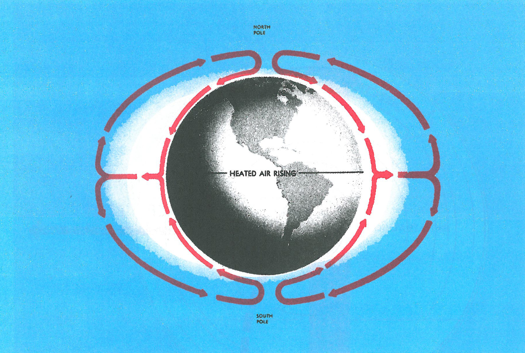
Pressure differences must create a force in order to drive the wind. This force is the pressure gradient force. The force is from higher pressure to lower pressure. Because of uneven heating of the Earth, surface pressure is low in warm equatorial regions and high in cold polar regions. A pressure gradient develops from the poles to the Equator. If the Earth did not rotate, this pressure gradient force would be the only force acting on the wind. Circulation would be two giant hemispheric convective currents as shown in figure 2. Cold air would sink at the poles; wind would blow straight from the poles to the Equator; warm air at the Equator would be forced upward; and high level winds would blow directly toward the poles. However, the Earth does rotate; and because of its rotation, this simple circulation is greatly distorted.
Coriolis Force
A moving mass travels in a straight line until acted on by some outside force. However, if one views the moving mass relative to his platform appears to be deflected or curved. A similar apparent force deflects moving particles on the earth. Because the Earth is spherical, the deflective force is much more complex.
The Coriolis force affects the paths of aircraft; missiles; flying birds; ocean currents; and, most important to the study of weather, air currents. The force deflects air to the right in the Northern Hemisphere. Coriolis force is at a right angle to wind direction and directly proportional to wind speed. That is, as wind speed increases, Coriolis force increases. At a given latitude, double the wind speed and you double the Coriolis force.
Coriolis force varies with latitude from zero at the Equator to a maximum at the poles. It influences wind direction everywhere except immediately at the Equator; but the effects are more pronounced in middle and high latitudes.
The General Circulation
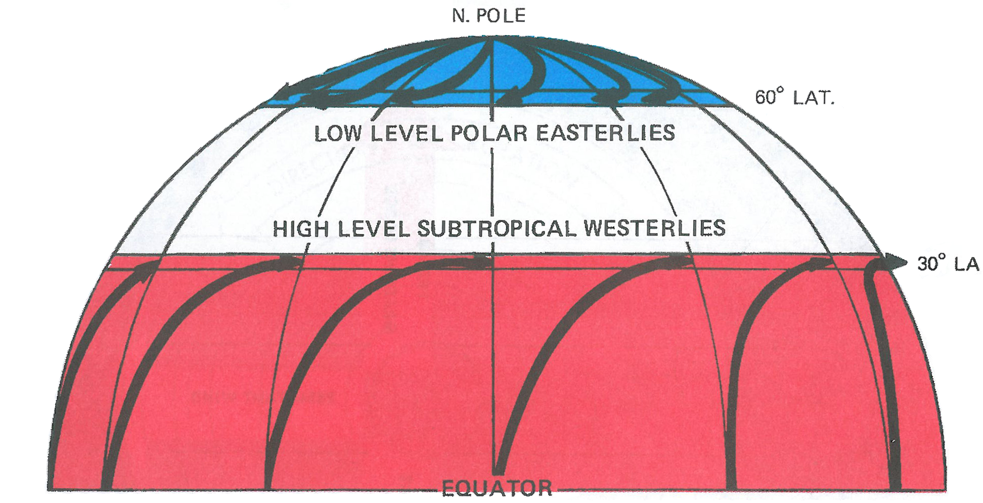
As air is forced aloft at the Equator and begins its high-level trek northward, the Coriolis force turns it to the right or to the east as shown in figure 3. Wind becomes westerly at about 30° latitude temporarily blocking further northward latitude temporarily blocking further northward movement. Similarly, as air over the poles begin its low-level journey southward toward the Equator, it likewise is deflected to the right and becomes an east wind, halting for a while its southerly progress–also shown in figure 3. As a result, air literally “piles up” at about 30° and 60° latitude in both hemispheres. The added weight of the air increases the pressure into semipermanent high pressure belts.
The building of these high pressure belts creates a temporary impasse disrupting the simple convective transfer between the Equator and the poles. The restless atmosphere cannot live with this impasse in its effort to reach equilibrium. Something has to give. Huge masses of air begin overturning in middle latitudes to complete the exchange.
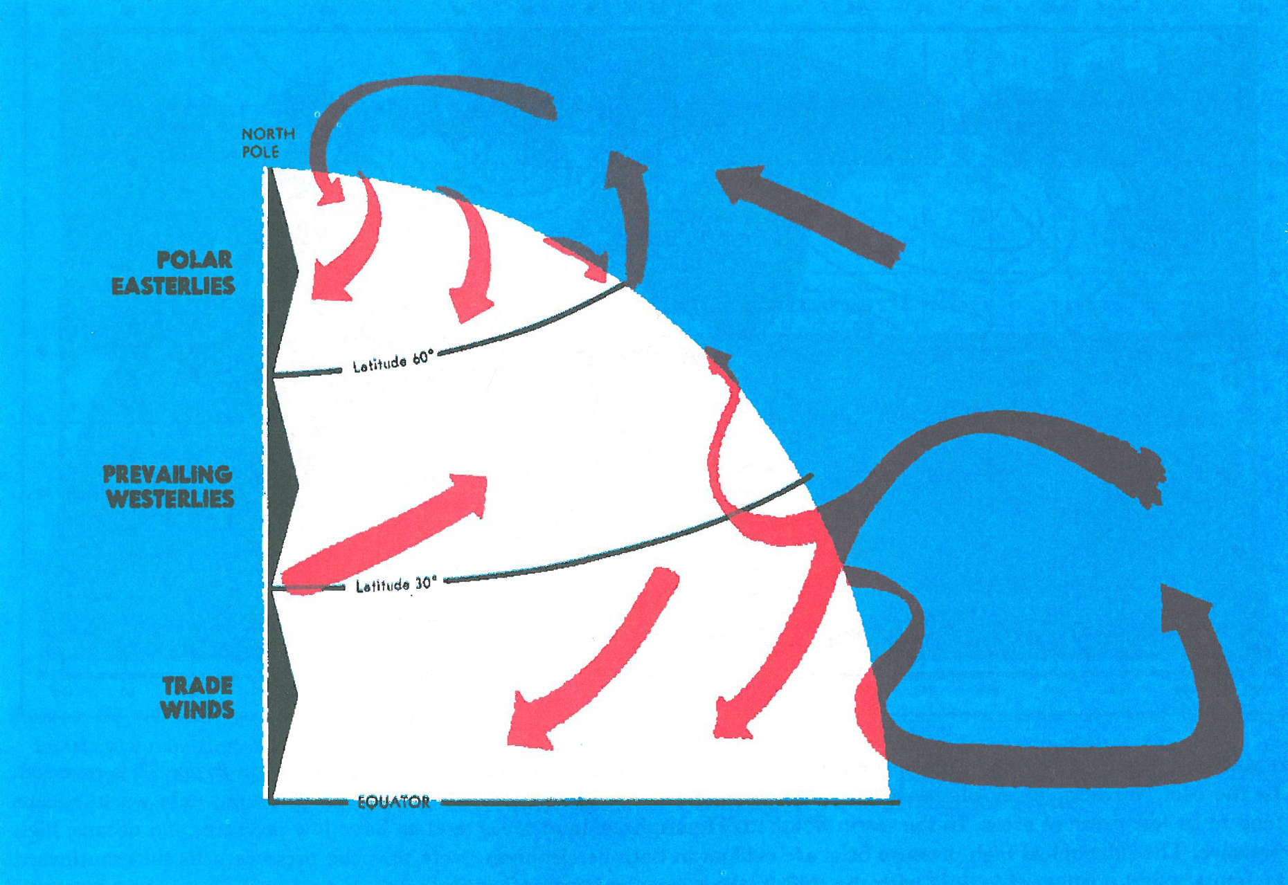
Large masses of cold air break through the northern barrier plunging southward toward the Tropics. Large midlatitude storms develop between cold outbreaks and carry warm air northward. The result is a midlatitude band of migratory storms with ever changing weather. Figure 4 is an attempt to standardize this chaotic circulation into an average general circulation.
Since pressure differences cause wind, seasonal pressure variations determine to a great extent the areas of these cold air outbreaks and midlatitude storms. But, seasonal temperature changes. We have learned that, at the surface, warm temperatures to a great extent determine low pressure and cold temperatures, high pressure. We have also learned that seasonal temperature changes over continents are much greater than over oceans.
During summer, warm continents tend to be areas of low pressure and the relatively cool oceans, high pressure. In winter, the reverse is true. As the air tries to blow outward from the high pressure, it is deflected to the right by the Coriolis force. Thus, the wind around a high blows clockwise. The high pressure with its associated wind system is an anticyclone.
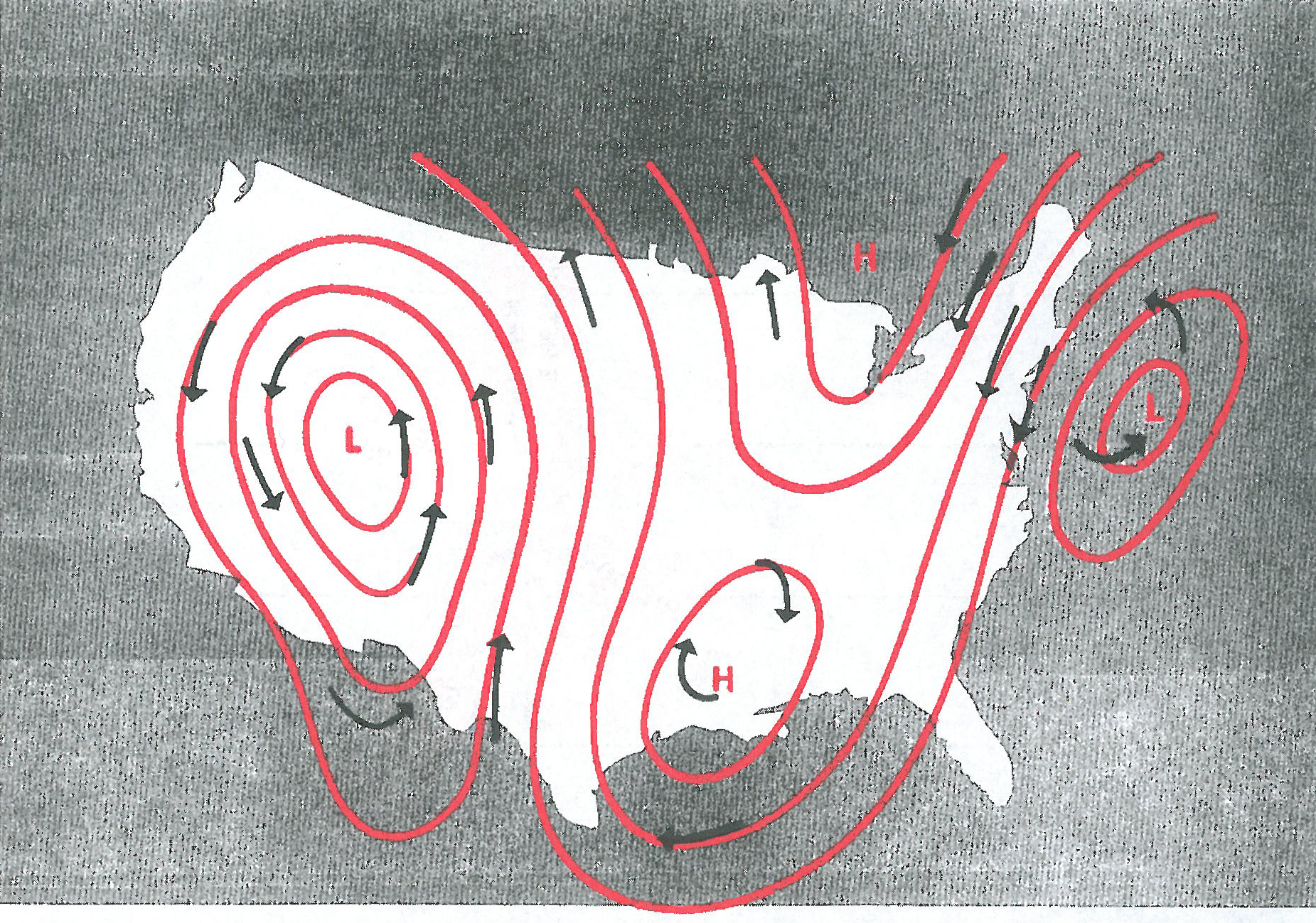
The storms that develop between high pressure systems are characterized by low pressure. As winds try to blow inward toward the center of low pressure, they also are deflected to the right. Thus, the wind around a low is counterclockwise. The low pressure and its wind system is a cyclone. Figure 5 shows winds blowing parallel to isobars (contours on upper level charts). The winds are clockwise around highs and counterclockwise around lows.
Be here Thursday for a post of Thunderstorms from our very own CFI. Thanks for following the Learn to Fly Blog!