Airport pavement markings and signs provide information useful to pilots during takeoff, landing, and taxiing. Uniformity in airport markings and signs from one airport to another enhances safety and improves efficiency. An illustrated guide to these markings, from Barry Schiff’s An Illustrated Guide to Flying is available in the Airport Markings and Signs Illustrated blog.
This introduction to markings and signs comes from the FAA’s Pilot’s Handbook of Aeronautical Knowledge. More on airport marking aids and signs, detailed with color images, can be found in Chapter 2 of the FAR/AIM, available from ASA in multiple formats.
Runway Markings
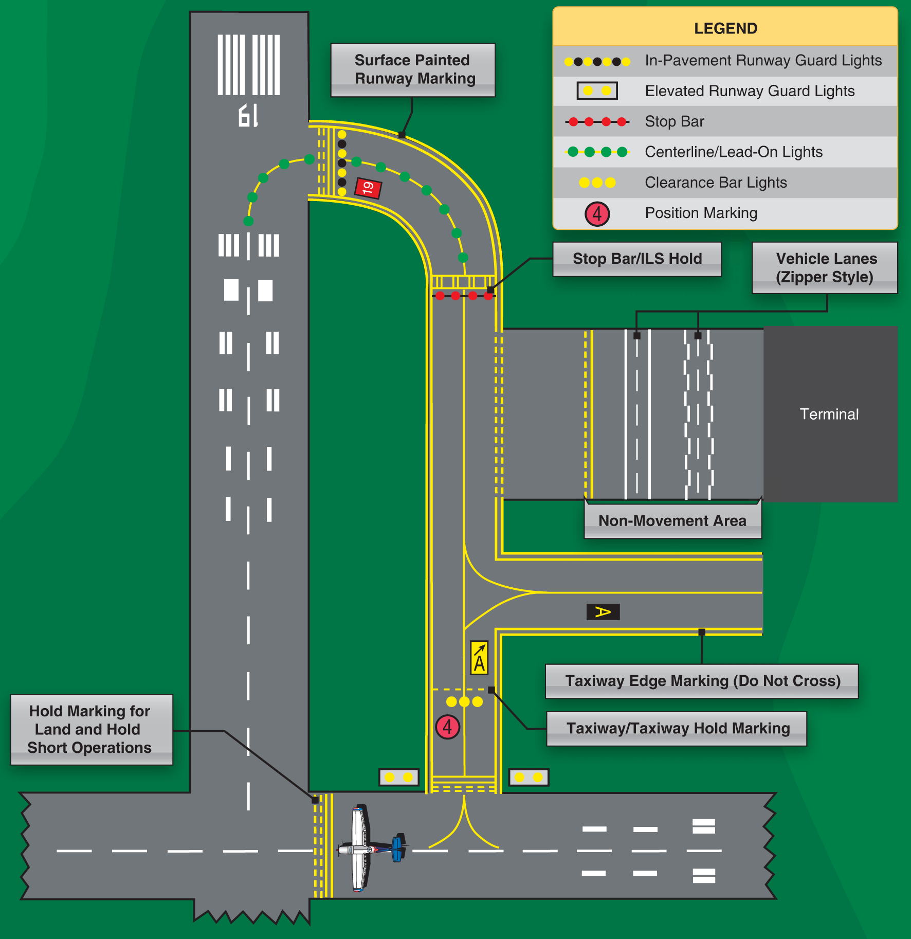
Runway markings vary depending on the type of operations conducted at the airport. Figure 1 shows a runway that is approved as a precision instrument approach runway and some other common runway markings. A basic VFR runway may only have centerline markings and runway numbers.
Since aircraft are affected by the wind during takeoffs and landings, runways are laid out according to the local prevailing winds. Runway numbers are in reference to magnetic north. Certain airports have two or even three runways laid out in the same direction. These are referred to as parallel runways and are distinguished by a letter added to the runway number (e.g., runway 36L (left), 36C (center), and 36R (right)).
Another feature of some runways is a displaced threshold. A threshold may be displaced because of an obstruction near the end of the runway. Although this portion of the runway is not to be used for landing, it may be available for taxiing, takeoff, or landing rollout. Some airports may have a blast pad/stopway area. The blast pad is an area where a propeller or jet blast can dissipate without creating a hazard. The stopway area is paved in order to provide space for an aircraft to decelerate and stop in the event of an aborted takeoff. These areas cannot be used for takeoff or landing.
Taxiway Markings
Aircraft use taxiways to transition from parking areas to the runway. Taxiways are identified by a continuous yellow centerline stripe and may include edge markings to define the edge of the taxiway. This is usually done when the taxiway edge does not correspond with the edge of the pavement. If an edge marking is a continuous line, the paved shoulder is not intended to be used by an aircraft. If it is a dashed marking, an aircraft may use that portion of the pavement. Where a taxiway approaches a runway, there may be a holding position marker. These consist of four yellow lines (two solid and two dashed). The solid lines are where the aircraft is to hold. At some towered airports, holding position markings may be found on a runway. They are used when there are intersecting runways, and ATC issues instructions such as “cleared to land—hold short of runway 30.”
Other Markings
Some other markings found on the airport include vehicle roadway markings, VOR receiver checkpoint markings, and non-movement area boundary markings.
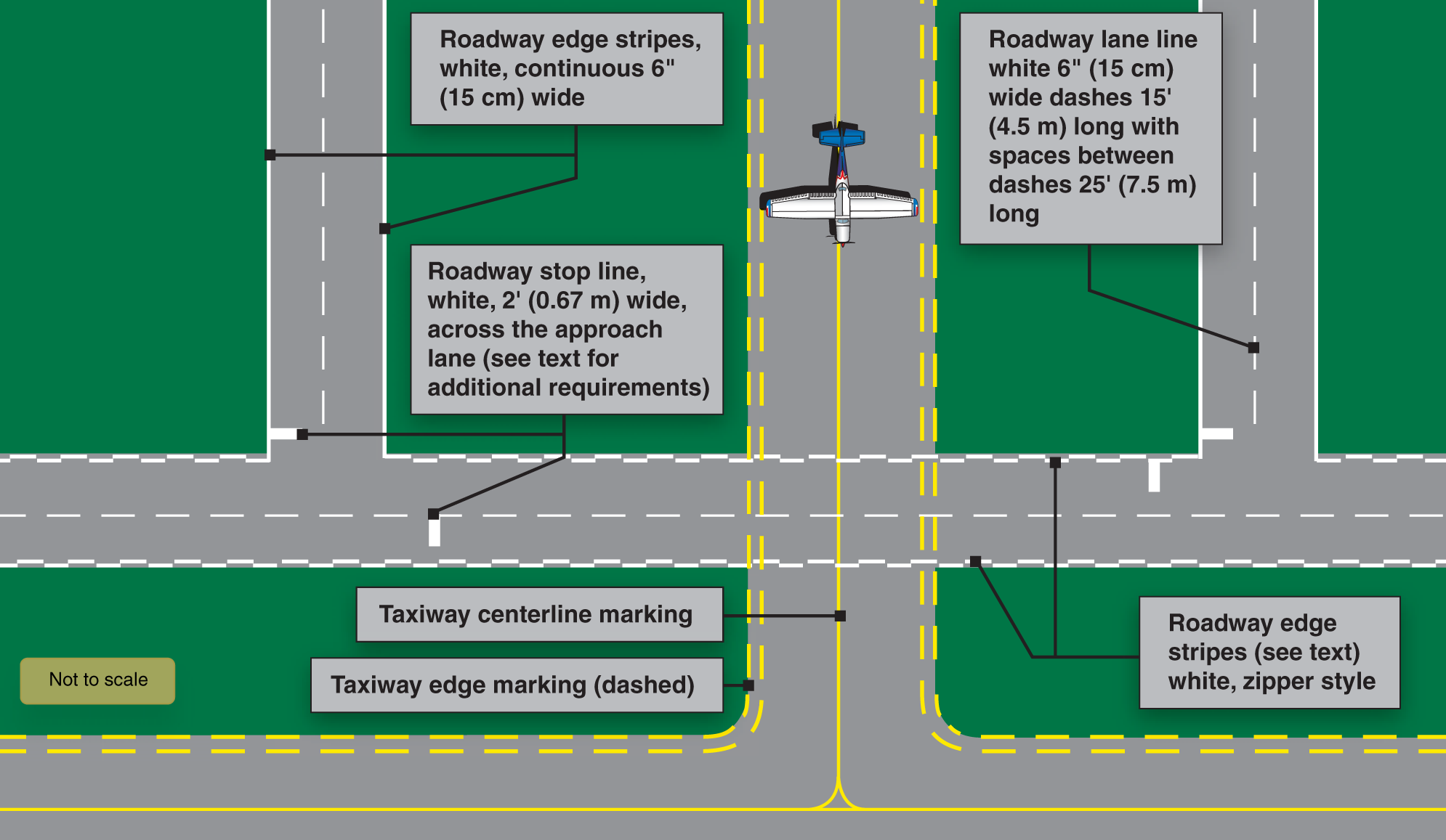
Vehicle roadway markings are used when necessary to define a pathway for vehicle crossing areas that are also intended for aircraft. These markings usually consist of a solid white line to delineate each edge of the roadway and a dashed line to separate lanes within the edges of the roadway. In lieu of the solid lines, zipper markings may be used to delineate the edges of the vehicle roadway. [Figure 2]
A VOR receiver checkpoint marking consists of a painted circle with an arrow in the middle. The arrow is aligned in the direction of the checkpoint azimuth. This allows pilots to check aircraft instruments with navigational aid signals.
A non-movement area boundary marking delineates a movement area under ATC. These markings are yellow and located on the boundary between the movement and nonmovement area. They normally consist of two yellow lines (one solid and one dashed).
Airport Signs
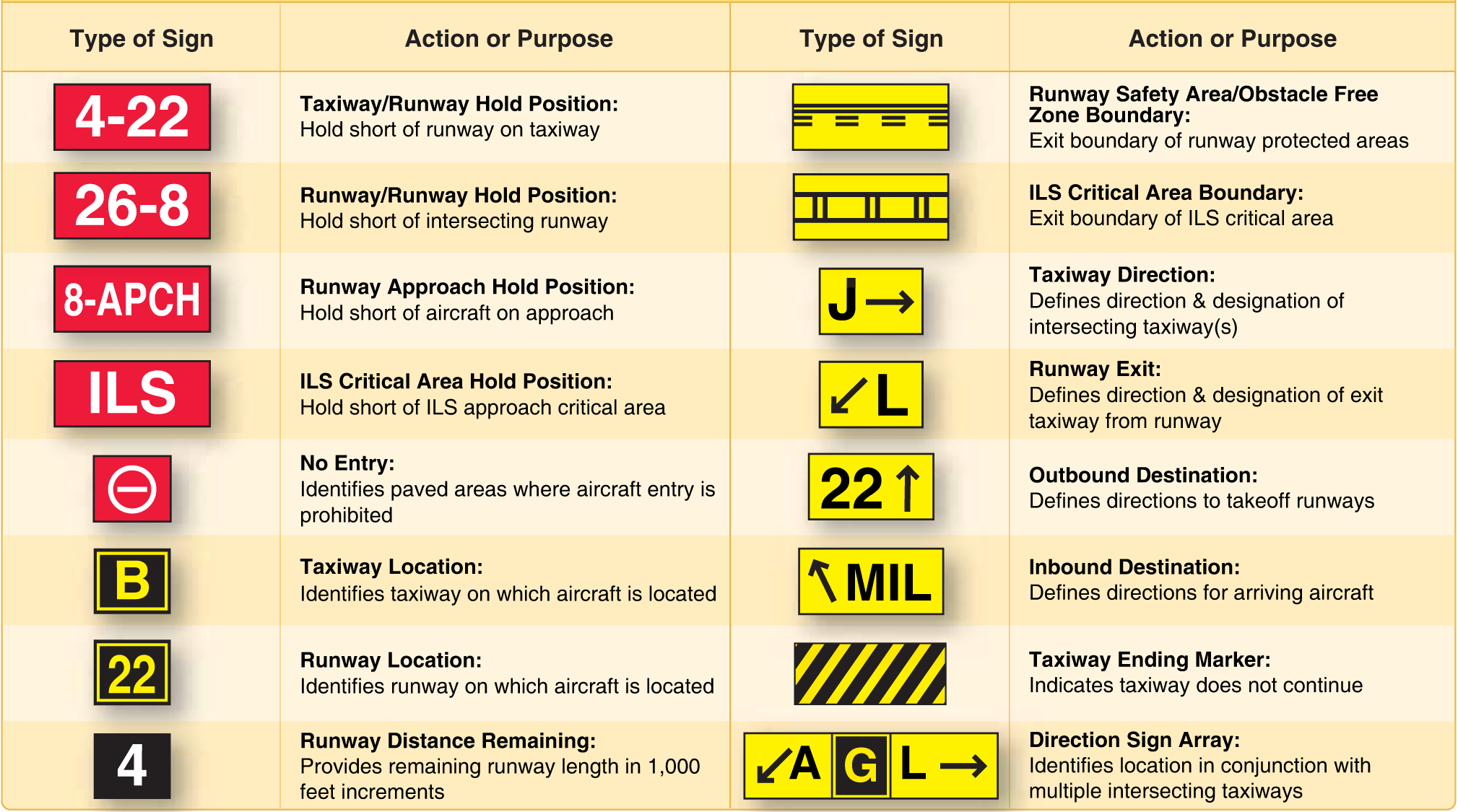
There are six types of signs that may be found at airports. The more complex the layout of an airport, the more important the signs become to pilots. Figure 3 shows examples of signs, their purpose, and appropriate pilot action. The six types of signs are:
- Mandatory instruction signs—red background with white inscription. These signs denote an entrance to a runway, critical area, or prohibited area.
- Location signs—black with yellow inscription and a yellow border, no arrows. They are used to identify a taxiway or runway location, to identify the boundary of the runway, or identify an instrument landing system (ILS) critical area.
- Direction signs—yellow background with black inscription. The inscription identifies the designation of the intersecting taxiway(s) leading out of an intersection.
- Destination signs—yellow background with black inscription and also contain arrows. These signs provide information on locating things, such as runways, terminals, cargo areas, and civil aviation areas.
- Information signs—yellow background with black inscription. These signs are used to provide the pilot with information on such things as areas that cannot be seen from the control tower, applicable radio frequencies, and noise abatement procedures. The airport operator determines the need, size, and location of these signs.
- Runway distance remaining signs—black background with white numbers. The numbers indicate the distance of the remaining runway in thousands of feet.
Be here Thursday for Part III of our CFI’s series on pitot-static instruments!
Feature image by Anonymous8010, CC BY-SA 4.0 https://creativecommons.org/licenses/by-sa/4.0, via Wikimedia Commons.