As a pilot or student pilot, you may see airport markings as simple or obvious, but to someone who has had less experience on the tarmac, they can seem quite complicated. One of ASA’s premier books for students, passengers, and future pilots, An Illustrated Guide to Flying offers information in bitesize pieces and visual representations that make the complex seem simple. Barry Schiff has created an exciting introduction to flying for aspiring pilots of all ages. Keep reading to see his insights on airports and their markings.

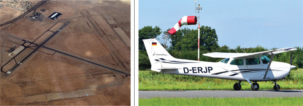
AIRPORTS come in all sizes and shapes. Some are large complexes with numerous long, concrete runways that are more than two miles long. Most, however, like the one below, have only one or two hard-surface runways a few thousand feet long. Others can be short dirt or grass strips carved from the wilderness. Seaports are designated areas of water on rivers or lakes that are used by seaplanes. Heliports are small areas not much larger in area than the helicopters that use them.
A runway is numbered according to its magnetic direction. The direction is rounded off to the nearest 10 degrees and the last digit is dropped. For example, the runway in the diagram is aligned east (090°) and west (270°). It is numbered 9 and 27, depending upon the direction of takeoff and landing. If an airport has two parallel runways, they might be labeled 9L (for the left runway) and 9R (for the right runway). When operating in the opposite direction, they would be labeled 27R and 27L. When there are three parallel runways, the center runway usually is labeled with a “C” (e.g., 9C and 27C).
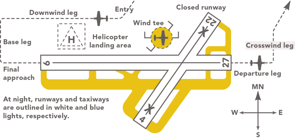
A TRAFFIC PATTERN is established to provide an organized flow of traffic about an airport. The standard traffic pattern in the United States is a left-hand pattern; the flow of traffic is counterclockwise. A right-hand (clockwise) pattern is used only when a left-hand pattern is impractical, such as when a portion of such a pattern would extend over a housing development. Using a right-hand pattern then places traffic on the other side of the airport and eliminates noise for those living under a left-hand pattern. The standard altitude at which airplanes fly in the traffic pattern varies from 600 to 1,500 feet above the airport elevation, but 1,000 feet is most common, and the altitude depends on local conditions and regulations. (The pattern altitude for military jets can be as high as 2,500 feet.)
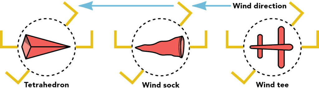
A WIND INDICATOR, enclosed in a large, segmented circle, is displayed at most airports. The three common types above, for example, show the wind blowing from the east, indicating that takeoffs and landings should be made on Runway 9 (into the wind and toward the east). The L-shaped indicators show that the use of Runway 9 requires a left-hand traffic pattern. When the wind blows from the west, pilots use Runway 27 and fly a right-hand pattern. A northeast wind would indicate use of Runway 4, and so forth. Sometimes the wind “splits” the runways, and the pilot has a choice of which one to use.
WHEN DEPARTING from an airport without a control tower, the pilot looks at the wind indicator to determine which runway and what type of traffic pattern to use. The pilot taxis to the runway and, when ready for takeoff, visually scans the vicinity of the airport to see that no one is about to land.
UPON ARRIVING at an airport without a control tower, the pilot flies over the airport at least 1,000 feet above traffic pattern altitude to look at the wind indicator and determine which runway and what type of traffic pattern to use. The pilot then flies away from the area, descends to pattern altitude, and enters the flow of traffic at a 45-degree angle to the runway.
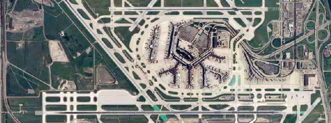
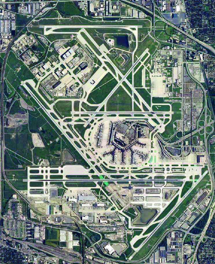
LARGE INTERNATIONAL AIRPORTS can look from above like complex spider webs of runways, taxiways, ramps, and terminal buildings. Some are as large as small cities. Chicago’s O’Hare International Airport has eight runways that total more than 74,000 feet in length.
The world’s busiest airport (in terms of passenger use) has consistently been the Hartsfield-Jackson International Airport in Atlanta, Georgia. The world’s largest airport (in square miles) is Saudi Arabia’s King Fahd International Airport.
Every airport has a unique three-letter location identifier. For example, pilots refer to Los Angeles International Airport as LAX, Seattle-Tacoma International Airport as SEA, and John F. Kennedy International Airport (serving New York City) as JFK. Airport identifiers in the contiguous United States are preceded by the letter K, such as KLAX, KSEA, KJFK, and so forth.
Pilots use airport diagrams to keep track of their position on the airport, keep their aircraft clear of conflict with other aircraft, and prevent them from crossing active runways without permission, a safety hazard called a runway incursion.
The next ASA Presents Author Talk will feature Captains Barry Schiff and Brian Schiff, who will discuss An Illustrated Guide to Flying and their combined love of flying. Watch live on October 12, 2023, at the ASA Presents website.


