
The GPS can be a great aid for situational awareness in VFR operations. Today, we’ll introduce the basics of how the system works. We’ll go more in depth on using the GPS in future posts. Learn more about the GPS and more navigation systems and instruments in The Pilot’s Manual Volume 2: Ground School.
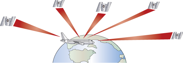
Precise point-to-point navigation is possible using satellite navigation systems that can compute aircraft position and altitude accurately by comparing signals from a global network of navigation satellites. The first global positioning systems (GPS) were designed for the U.S. Department of Defense, but in the early 1990s, GPS was made available for civil use. Later, full system accuracy was also made available.
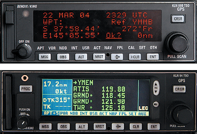
Each satellite transmits its own computer code packet on frequency 1,575.42 MHz (for civilian use) 1,000 times a second. The satellite constellation typically guarantees that at least four satellites are in view and usable for positioning at any one time from any position on earth. GPS equipment pinpoints an aircraft’s horizontal position in lat.-long. coordinates, similar to other long-range navigation systems, such as VLF/Omega; in the case of most aviation units, it then turns the information into a graphical moving map display of the aircraft’s position in relation to surrounding airspace on an LCD or CRT screen. Most GPS receivers can also display a CDI presentation, along with track, present position, actual time (to an accuracy of a few nanoseconds), groundspeed, time and distance to the next waypoint, and the current altitude of the aircraft.
GPS units have been approved for both en route and approach navigation, but, as with LORAN, not all units are
approved for anything other than situational awareness. IFR units must have their databases updated on a regular basis to remain IFR certified.
Nonprecision GPS approaches are available at most U.S. airports today. Precision GPS approaches using a ground station to augment the satellite signals is coming soon. This wide area augmentation system (WAAS) will allow GPS to be used as the primary NAVAID from takeoff through to approach.
Some manufacturers have produced multi-function displays (MFDs), which combine data from conventional flight instruments and on-board fuel/air data sensors for light aircraft.
The GPS has three functional elements:
- a space segment;
- a control segment; and
- a user segment (the airborne receivers).
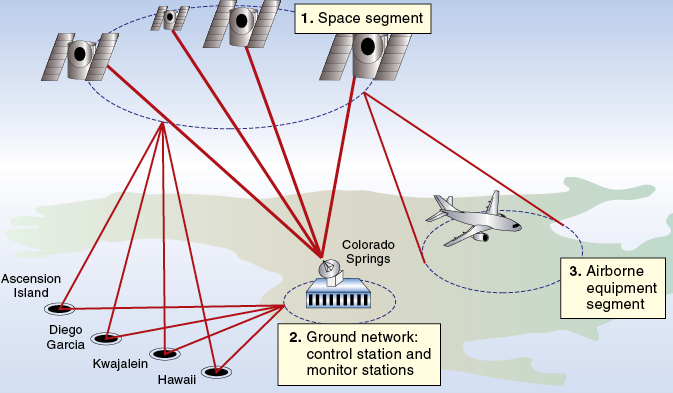
Space Segment
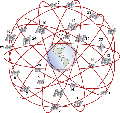
The space segment consists of a constellation of 24 satellites orbiting the earth at an altitude of just over 20,200 km (10,900 NM) in six, strategically defined orbital planes. The objective of the GPS satellite configuration is to provide a window of at least four satellites in view from any point on earth. The satellites orbit at an inclination angle of 55° (they cross the equator northeast bound at an angle of 55°), taking approximately 12 hours to complete an orbit, and the orbital position of each satellite is known precisely at all times.
Control Segment
The control segment includes monitoring stations at various locations around the world, ground antennas and up-links, and a master station. The stations track all satellites in view, passing information to a master control station, which controls the satellites’ clock and orbit states and the currency of the navigation messages. Satellites are frequently updated with new data for the compilation of the navigation messages transmitted to system users. Assuming the current level of space vehicle technology, the planned life span of a GPS satellite is around seven to eight years, but many function long after that.
User Segment (the Receiver)
The receiver identifies each satellite being received. Displays for the pilot vary from one GPS unit to another. Flight planning data is usually entered via an appropriate keypad on a control display unit (CDU) or control panel. The usual navigation information—i.e. position (POS), track (TRK), groundspeed (GS), EET, and, with TAS and MH input, wind direction and velocity—is displayed. The unit must also be capable of showing satellite status, satellites in view and being tracked,and signal quality.
Featured image by KissShot at adobe stock.com.


