Observed weather condition reports are often used in the creation of forecasts for the same area. A variety of different forecast products are produced and designed to be used in the preflight planning stage. The printed forecasts that pilots need to be familiar with are the terminal aerodrome forecast (TAF), aviation area forecast (FA), inflight weather advisories (SIGMET, AIRMET), and the winds and temperatures aloft forecast (FD). Today, we’ll take a closer look at the FA. This post is excerpted from the Pilot’s Handbook of Aeronautical Knowledge.
The FA gives a picture of clouds, general weather conditions, and visual meteorological conditions (VMC) expected over a large area encompassing several states. There are six areas for which area forecasts are published in the contiguous 48 states. Area forecasts are issued three times a day and are valid for 18 hours. This type of forecast gives information vital to en route operations, as well as forecast information for smaller airports that do not have terminal forecasts.
Area forecasts are typically disseminated in four sections and include the following information:
1. Header—gives the location identifier of the source of the FA, the date and time of issuance, the valid forecast time, and the area of coverage.
Example:
DFWC FA 120945
SYNOPSIS AND VFR CLDS/WX
SYNOPSIS VALID UNTIL 130400
CLDS/WX VALID UNTIL 122200…OTLK VALID 122200-130400
OK TX AR LA MS AL AND CSTL WTRS
Explanation:
The area forecast shows information given by Dallas Fort Worth, for the region of Oklahoma, Texas, Arkansas, Louisiana, Mississippi, and Alabama, as well as a portion of the Gulf coastal waters. It was issued on the 12th day of the month at 0945. The synopsis is valid from the time of issuance until 0400 hours on the 13th. VFR clouds and weather information on this area forecast are valid until 2200 hours on the 12th and the outlook is valid until 0400 hours on the 13th.
2. Precautionary statements—IFR conditions, mountain obscurations, and thunderstorm hazards are described in this section. Statements made here regarding height are given in MSL, and if given otherwise, AGL or ceiling (CIG) will be noted.
Example:
SEE AIRMET SIERRA FOR IFR CONDS AND MTN OBSCN.
TS IMPLY SEV OR GTR TURB SEV ICE LLWS AND IFR CONDS.
NON MSL HGTS DENOTED BYAGL OR CIG.
Explanation:
The area forecast covers VFR clouds and weather, so the precautionary statement warns that AIRMET Sierra should be referenced for IFR conditions and mountain obscuration. The code TS indicates the possibility of thunderstorms and implies there may be occurrences of severe or greater turbulence, severe icing, low-level wind shear, and IFR conditions. The final line of the precautionary statement alerts the user that heights, for the most part, are MSL. Those that are not MSL will be AGL or CIG
3. Synopsis—gives a brief summary identifying the location and movement of pressure systems, fronts, and circulation patterns.
Example:
SYNOPSIS…LOW PRES TROF 10Z OK/TX PNHDL AREA FCST MOV EWD INTO CNTRL-SWRN OK BY 04Z. WRMFNT 10Z CNTRL OK-SRN AR-NRN MS FCST LIFT NWD INTO NERN OK-NRN AR EXTRM NRN MS BY 04Z.
Explanation:
As of 1000Z, there is a low pressure trough over the Oklahoma and Texas panhandle area, which is forecast to move eastward into central southwestern Oklahoma by 0400Z. A warm front located over central Oklahoma, southern Arkansas, and northern Mississippi at 1000Z is forecast to lift northwestward into northeastern Oklahoma, northern Arkansas, and extreme northern Mississippi by 0400Z.
4. VFR Clouds and Weather—This section lists expected sky conditions, visibility, and weather for the next 12 hours and an outlook for the following 6 hours.
Example:
S CNTRL AND SERN TX
AGL SCT-BKN010. TOPS 030. VIS 3-5SM BR. 14-16Z BECMG AGL SCT030. 19Z AGL SCT050.
OTLK…VFR
OK
PNDLAND NW…AGL SCT030 SCT-BKN100.
TOPS FL200.
15Z AGL SCT040 SCT100. AFT 20Z SCT TSRA DVLPG.. FEW POSS SEV. CB TOPS FL450.
OTLK…VFR
Explanation:
In south central and southeastern Texas, there is a scattered to broken layer of clouds from 1,000 feet AGL with tops at 3,000 feet, visibility is 3 to 5 sm in mist. Between 1400Z and 1600Z, the cloud bases are expected to increase to 3,000 feet AGL. After 1900Z, the cloud bases are expected to continue to increase to 5,000 feet AGL and the outlook is VFR.
In northwestern Oklahoma and panhandle, the clouds are scattered at 3,000 feet with another scattered to broken layer at 10,000 feet AGL, with the tops at 20,000 feet. At 1500Z, the lowest cloud base is expected to increase to 4,000 feet AGL with a scattered layer at 10,000 feet AGL. After 2000Z, the forecast calls for scattered thunderstorms with rain developing and a few becoming severe; the CB clouds will have tops at flight level 450 or 45,000 feet MSL.
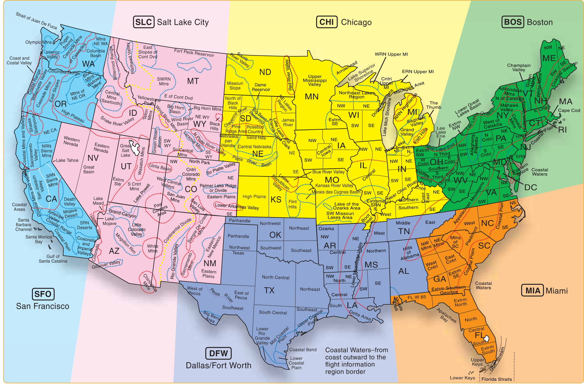
It should be noted that when information is given in the area forecast, locations may be given by states, regions, or specific geological features such as mountain ranges. Figure 1 shows an area forecast chart with six regions of forecast, states, regional areas, and common geographical features.
Check back in on Thursday for an EAA AirVenture 2015 dispatch from our CFI! Come see us in Hangar B at booth 2075-2079 this week!