
Out here in the Pacific Northwest, we’re used to what’s generally characterized as “bad” weather. And since we’re setting regional rainfall records right now, let’s talk about weather. Specifically, fronts.
As an air mass moves across bodies of water and land, it eventually comes into contact with another air mass with different characteristics. The boundary layer between two types of air masses is known as a front. An approaching front of any type always means changes to the weather are imminent. There are four types of fronts, which are named according to the temperature of the advancing air relative temperature to the air mass it is replacing: warm, cold, stationary, and occluded.
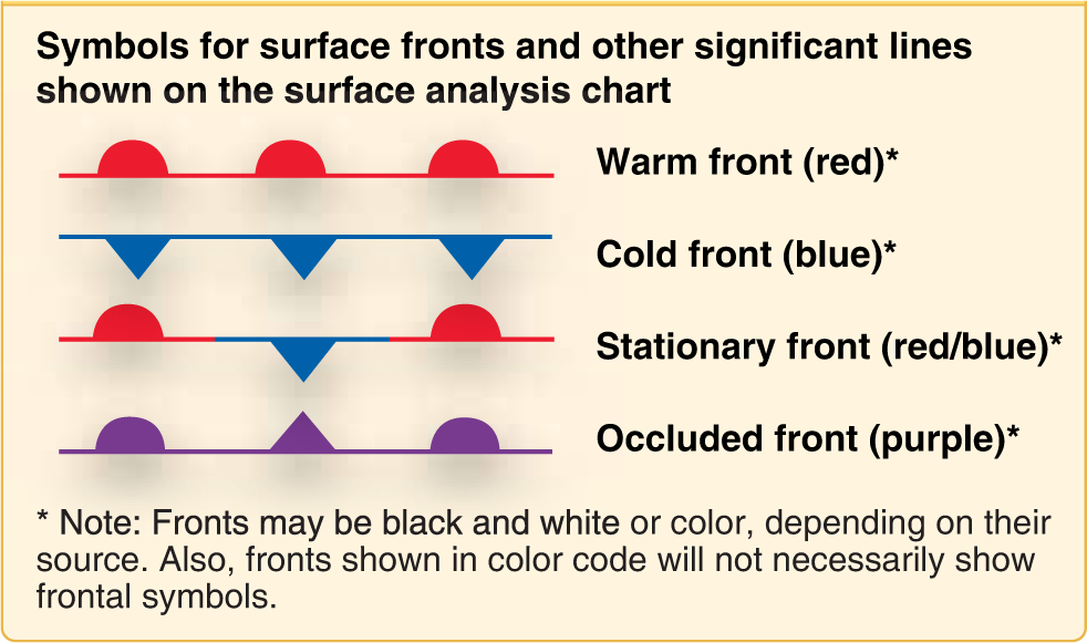
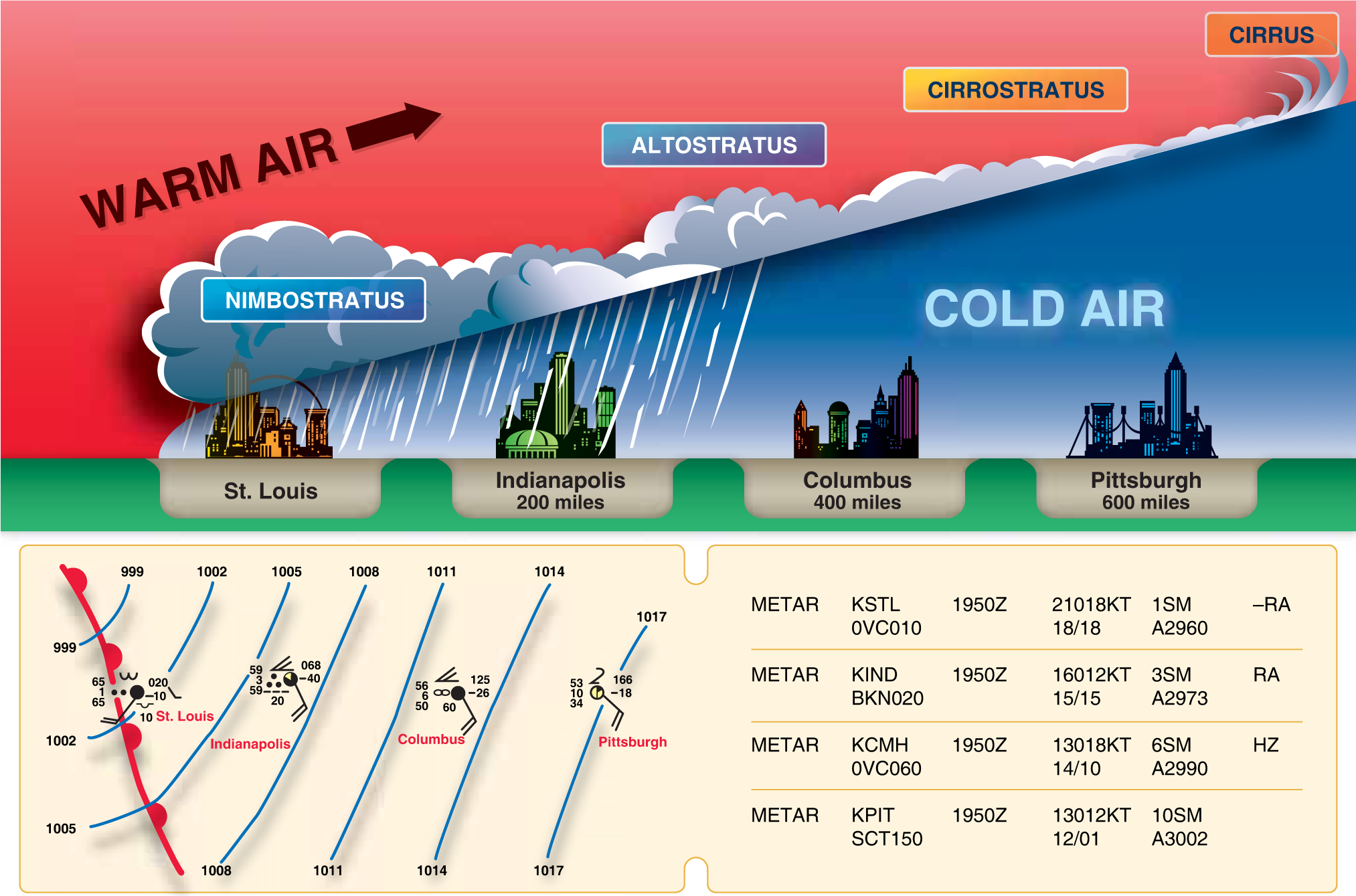
Warm Fronts
A warm front occurs when a warm mass of air advances and replaces a body of colder air. Warm fronts move slowly, typically 10 to 25 miles per hour (mph). The slope of the advancing front slides over the top of the cooler air and gradually pushes it out of the area. Warm fronts contain warm air that often have very high humidity. As the warm air is lifted, the temperature drops and condensation occurs. Generally, prior to the passage of a warm front, cirriform or stratiform clouds, along with fog, can be expected to form along the frontal boundary. In the summer months, cumulonimbus clouds (thunderstorms) are likely to develop. Light to moderate precipitation is probable, usually in the form of rain, sleet, snow, or drizzle, accentuated by poor visibility.
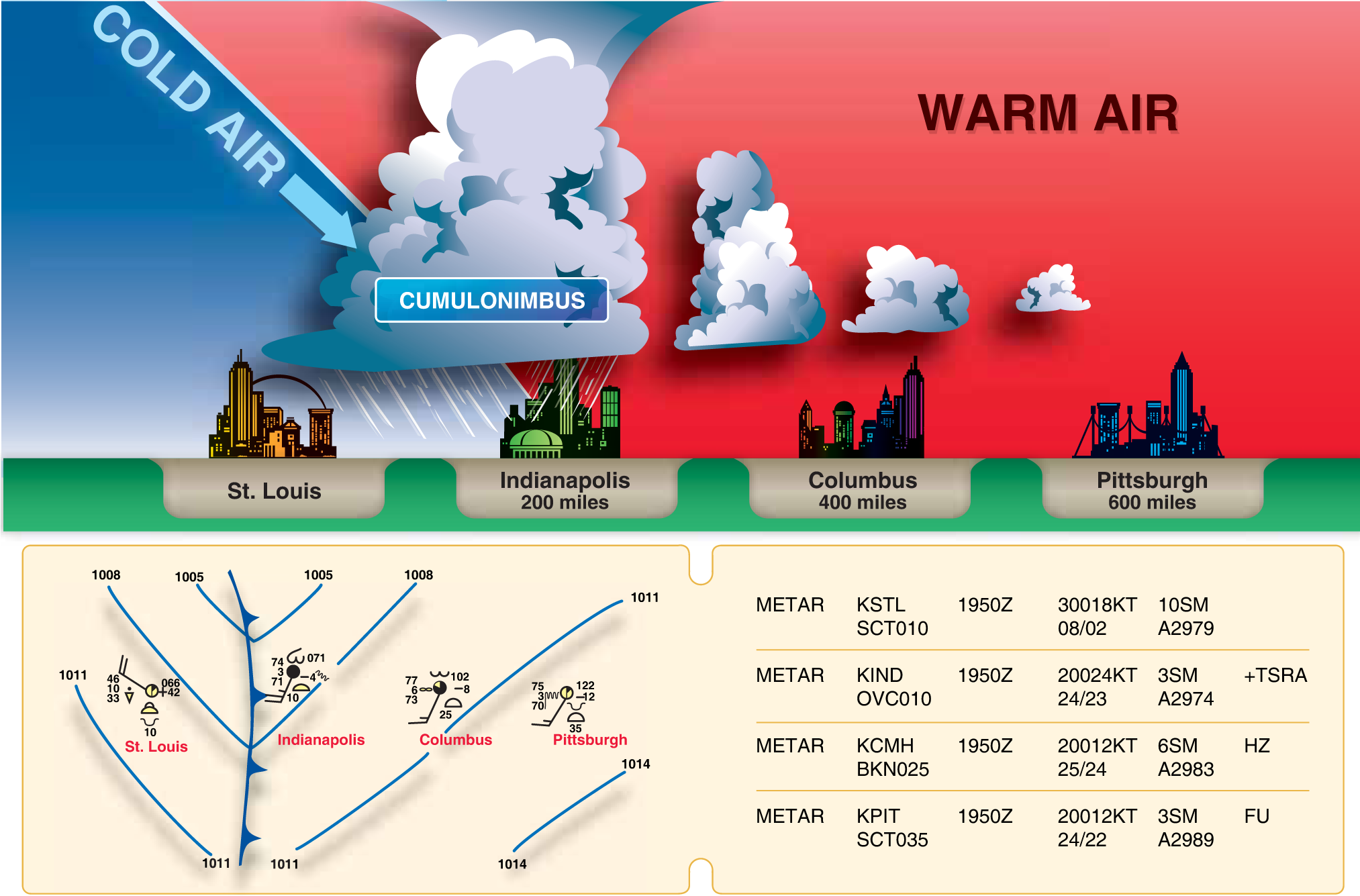
Cold Front
Cold fronts move more rapidly than warm fronts, progressing at a rate of 25 to 30 mph. However, extreme cold fronts have been recorded moving at speeds of up to 60 mph. A typical cold front moves in a manner opposite that of a warm front. It is so dense, it stays close to the ground and acts like a snowplow, sliding under the warmer air and forcing the less dense air aloft. The rapidly ascending air
causes the temperature to decrease suddenly, forcing the creation of clouds. The type of clouds that form depends on the stability of the warmer air mass. A cold front in the Northern Hemisphere is normally oriented in a northeast to southwest manner and can be several hundred miles long, encompassing a large area of land. Rain showers and haze are possible due to the rapid development of clouds.
Depending on the intensity of the cold front, heavy rain showers form and might be accompanied by lightning, thunder, and/or hail. More severe cold fronts can also produce tornadoes. During cold front passage, the visibility is poor, with winds variable and gusty, and the temperature and dew point drop rapidly.
Stationary Front
When the forces of two air masses are relatively equal, the boundary or front that separates them remains stationary and influences the local weather for days. This front is called a stationary front. The weather associated with a stationary front is typically a mixture that can be found in both warm and cold fronts.
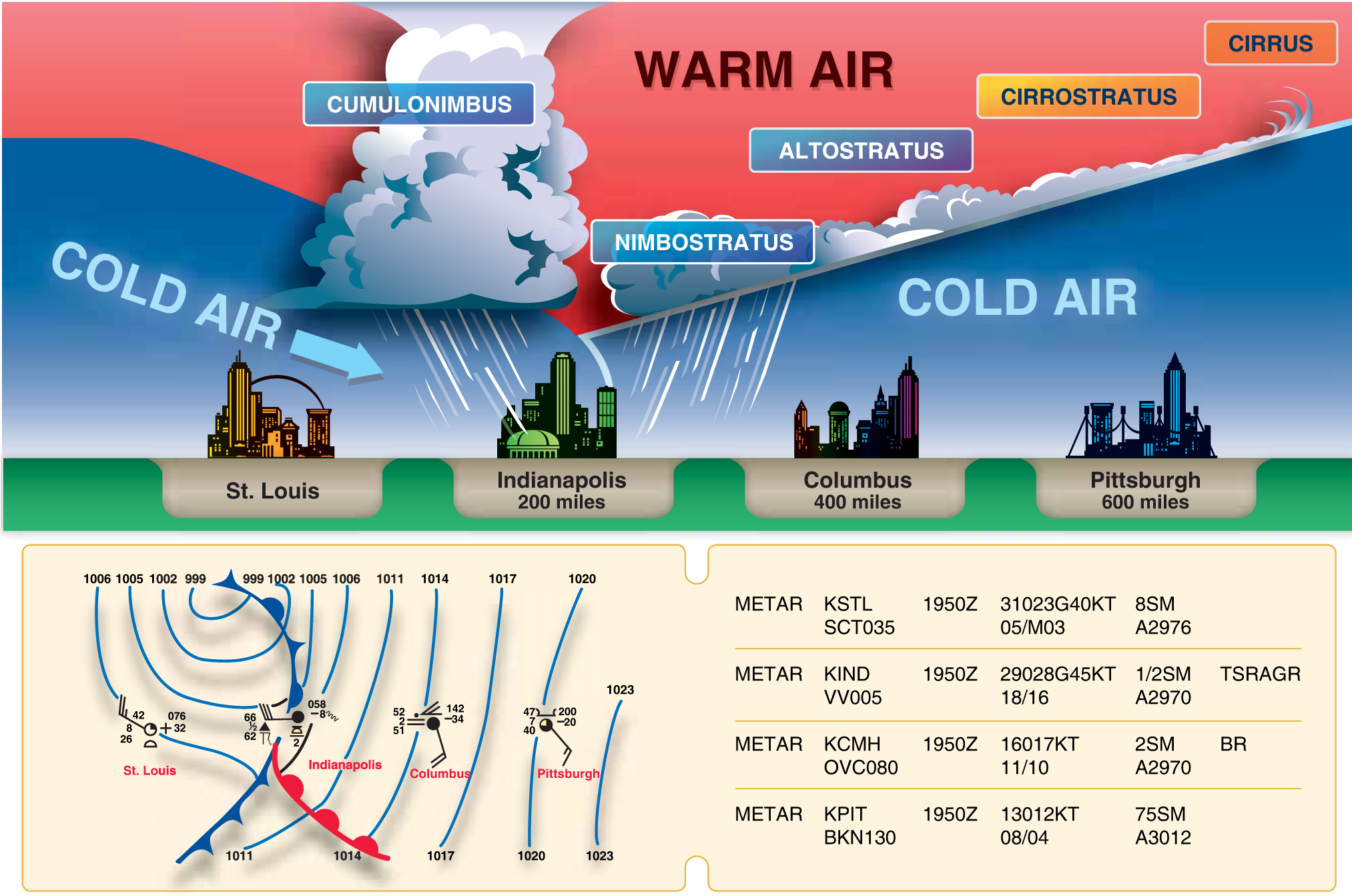
Occluded Front
An occluded front occurs when a fast-moving cold front catches up with a slow-moving warm front. As the occluded front approaches, warm front weather prevails, but is immediately followed by cold front weather. A cold front occlusion occurs when a fast moving cold front is colder than the air ahead of the slow moving warm front. When this occurs, the cold air replaces the cool air and forces the warm front aloft into the atmosphere. Typically, the cold front occlusion creates a mixture of weather found in both warm and cold fronts, providing the air is relatively stable.
A warm front occlusion occurs when the air ahead of the warm front is colder than the air of the cold front. When this is the case, the cold front rides up and over the warm front. If the air forced aloft by the warm front occlusion is unstable, the weather is more severe than the weather found in a cold front occlusion. Embedded thunderstorms, rain, and fog are likely to occur.
ASA’s offices will be closed December 31 and January 1. Happy New Year!
Featured image by Tobias Hämmer from Pixabay.


