This week you and I have been tasked with repositioning a Cessna 172 from the Savannah Airport (SAV) to Allendale County (88J) — airports neither of us has ever flown out of. To begin our planning we have obtained the local sectional chart to gain all available information from this important resource regarding our planned flight.
The first thing I like to do is look at the big picture to determine what types of airspace and other pertinent issues will affect the route of flight including terrain, aids to navigation, and aerial hazards to flight, such as parachute or glider activity. Notice that our departure point (SAV) is surrounded by a solid magenta line signifying it is within Class C airspace from the surface up to 4,100 feet, as noted by the 41/SFC indication. Looking north, our arrival airport (88J) is surrounded by a thick shaded magenta line, which tells us Class E airspace begins at 700 feet AGL with Class G below. Other than our departure airport, there is no other significant airspace along our route that we will need to deal with.
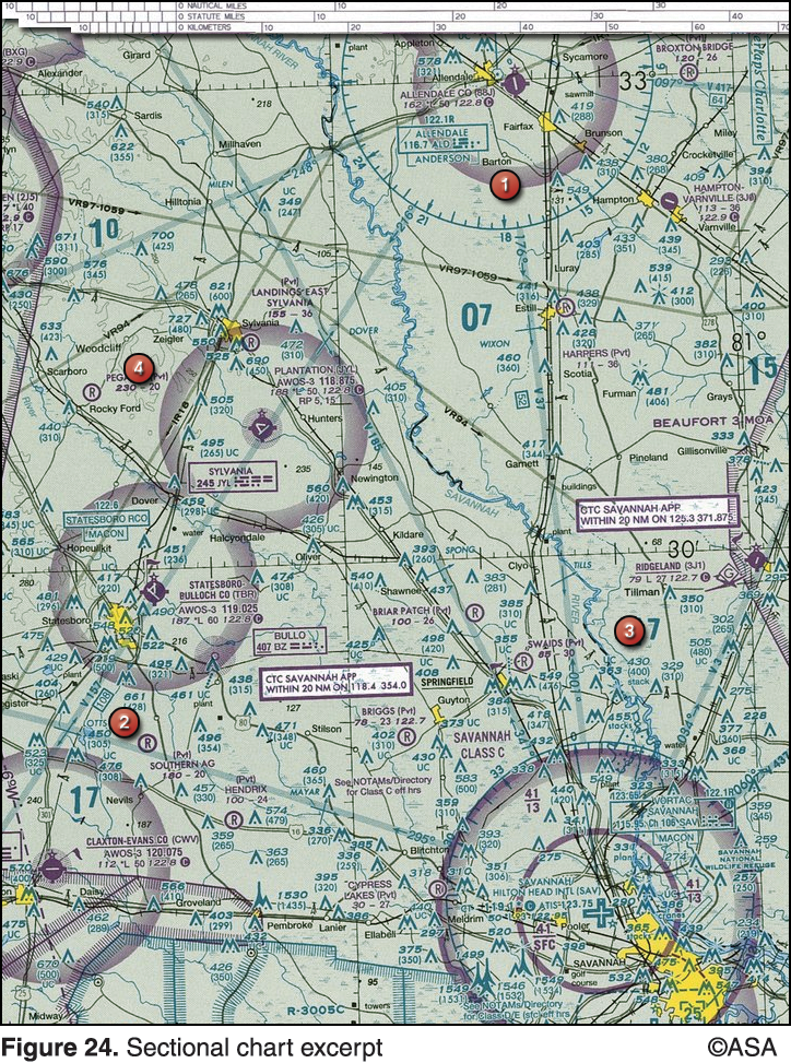
Next, let’s look at local terrain features. The topography is shaded a light green color; this tells us it is a fairly flat area with no terrain over 2,000 feet MSL (remember we learned this in Monday’s post). Also, notice the maximum elevation figures along our route indicated as 17 (area 3) and 07 (area 1); flying above these altitudes means we will be clear of terrain or any vertical obstacles. The Savannah River that flows north to south will be a good visual aid to navigation while en route. The sectional depicts a VOR over both our departure and arrival points; there’s even a Victor airway (V37) that we may want to use to navigate to our destination. Fortunately there don’t appear to be any aerial hazards or areas where we need to exercise extreme caution along our route (which might be depicted by a glider or parachute icon).
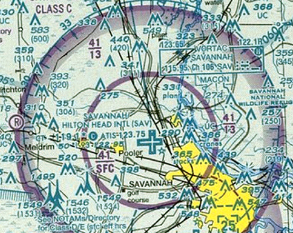
Let’s take a closer look at the areas surrounding both our departure and arrival airports to see what additional information we can gather. To the left of the SAV airport we can see the airport data listed. In the order they are listed, we can see the airport has an operating control tower and can be reached on frequency 119.1 (CT 119.1*); the star indicates the tower operates part-time. Following tower frequency is a “C” notating that during hours the tower is closed this frequency should be used as a CTAF. Also on the first line, the ATIS frequency is shown as 123.75. The next line provides additional information about the airport: 50 indicates the airport elevation as 50 feet MSL, followed by *L indicating the airport has lighting limitations. The “93” tells us the longest runway is 9,300 feet, and lastly the UNICOM frequency is listed as 122.95.
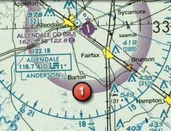
Our arrival airport, 88J or Allendale County, is depicted as a solid magenta circle with tick marks and a star above. Magenta signifies no control tower in operation, the star tells us a rotating airport beacon is in operation sunset to sunrise, and the tick marks let us know that services like fuel are available during normal working hours. We can interpret the airport data to the left as saying the airport elevation is 162 feet MSL, there’s lighting restrictions, the longest runway is 5,000 feet, and the common traffic advisory frequency is 122.8.
At this point we have accomplished our initial objective of gathering all available information from the sectional chart. This has allowed us to gain an overall picture of our scheduled repositioning flight to SAV. From here, we would gather additional resources and information by using the Airport/Facility Directory, Weather Reports, Local NOTAMs, and finally, completing a flight plan.
Do you notice anything else from the sectional that would be good to note – anything that may affect our decision making, flight planning, or inflight operation? Let us know in the comments section below.