
That little green book I’m sure you’ve seen lying around the FBO or on the briefing room table in the flight school actually packs a punch. As you learned in Monday’s post, it contains a wealth of crucial information that every pilot requires for pre-flight planning purposes. Just to recap a few key points regarding the Airport/Facility Directory (A/FD):
- The A/FD is a publication designed primarily as a pilot’s operational manual containing all airports, seaplane bases, and heliports open to the public including communications data, navigational facilities, and certain special notices and procedures.
- Directories are reissued in their entirety every 56 days.
- The A/FD is published in 9 volumes based on geographic region, 7 over contiguous United States + Alaska and the Pacific.
- A digital version is available (d-A/FD) and can be accessed right from the FAA website. Access d-A/FD.
It is almost a guarantee that you will be asked at least one question regarding the A/FD on your Private Pilot Knowledge Exam. Because of the wealth of information provided in this publication, an extensive legend is available in Appendix 1 of the Airman Knowledge Testing Supplement (you will have complete access to this supplement during testing). Yes, that means you don’t have to memorize what every little symbol means, it’s all outlined for you in the legend! With that said, let’s take a look at a few sample questions. Remember if you don’t know where to find the answer use the legend, I’ve included a link to it, Knowledge Testing Supplement (refer to appendix 1, legends 2-19).
1. For a complete listing of information provided in an Airport/Facility Directory (A/FD) and how the information may be decoded, refer to the
A—’Directory Legend Sample’ located in the front of each A/FD.
B—Aeronautical Information Manual (AIM).
C—legend on sectional and VFR terminal area charts.
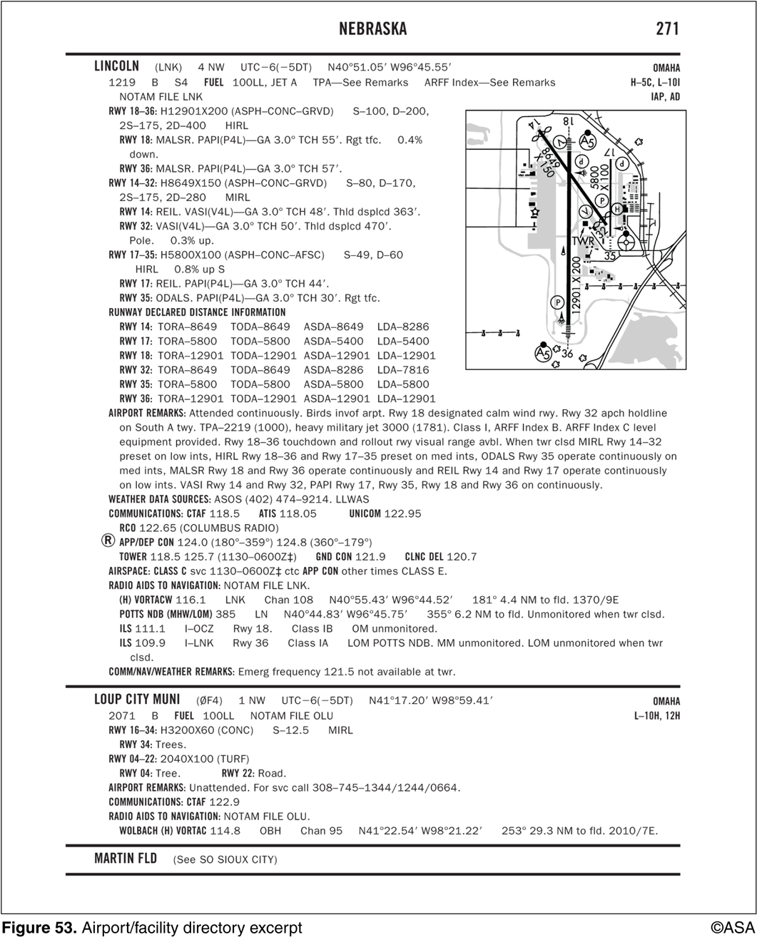
2. (Refer to Figure 53.) Where is Loup City Municipal located with relation to the city?
A—Northeast approximately 3 miles.
B—Northwest approximately 1 mile.
C—East approximately 7 miles.
3. (Refer to Figure 53.) Which type radar service is provided to VFR aircraft at Lincoln Municipal?
A—Sequencing to the primary Class C airport and standard separation.
B—Sequencing to the primary Class C airport and conflict resolution so that radar targets do not touch, or 1,000 feet vertical separation.
C—Sequencing to the primary Class C airport, traffic advisories, conflict resolution, and safety alerts.
4. (Refer to Figure 53.) What is the recommended communications procedure for landing at Lincoln Municipal during the hours when the tower is not in operation?
A—Monitor airport traffic and announce your position and intentions on 118.5 MHz.
B—Contact UNICOM on 122.95 MHz for traffic advisories.
C—Monitor ATIS for airport conditions, then announce your position on 122.95 MHz.
Think you got them all right? I hope so! Scroll down for the answers.
⇓
⇓
⇓
⇓
⇓
⇓
⇓
⇓
1. (Answer A). For a complete listing of information provided in an A/FD and how the information may be decoded, refer to the ‘Directory Legend Sample’ located in the front of each A/FD.
2. (Answer B). Airport location is expressed as distance and direction from the center of the associated city in NM and cardinal points. The first item in parentheses is the airport identifier and the second item is the relation from the city. In this case, ‘1 NW.’
3. (Answer C). Radar service in Class C airspace consists of sequencing to the primary airport, standard IFR/IFR separation, IFR/VFR separation (so that targets do not touch or have less than 500-foot separation), and providing traffic advisories and safety alerts.
4. (Answer A). At an airport where the tower is operated on a part-time basis, a pilot should self-announce on the CTAF.


