[Update: In December 2022, the FAA published the Aviation Weather Handbook (FAA-H-8083-28) which replaced Advisory Circulars 00-6 and 00-45.]
We’re seeing rain for the first time in over two months in the Seattle area right now, so how about a refresher on precipitation today on the Learn to Fly Blog? Today’s post is excerpted from Aviation Weather (AC 00-6B).
Precipitation is any of the forms of water particles, whether liquid or solid, that fall from the atmosphere and reach the ground. The precipitation types are: drizzle, rain, snow, snow grains, ice crystals, ice pellets, hail, and small hail and/or snow pellets.
Precipitation formation requires three ingredients: water vapor, sufficient lift to condense the water vapor into clouds, and a growth process that allows cloud droplets to grow large and heavy enough to fall as precipitation. Significant precipitation usually requires clouds to be at least 4,000 feet thick. The heavier the precipitation, the thicker the clouds are likely to be. When arriving or departing from an airport reporting precipitation of light or greater intensity, expect clouds to be more than 4,000 feet thick.
All clouds contain water, but only some produce precipitation. This is because cloud droplets and/or ice crystals are too small and light to fall to the ground as precipitation. Because of their microscopic size, the rate at which cloud droplets fall is incredibly slow. An average cloud droplet falling from a cloud base at 3,300 feet (1,000 meters) would require about 48 hours to reach the ground. It would never complete this journey because it would evaporate within minutes after falling below the cloud base. Two growth processes exist which allow cloud droplets (or ice crystals) to grow large enough to reach the ground as precipitation before they evaporate (or sublimate). One process is called the collision-coalescence, or warm rain process (see Figure 14-1). In this process, collisions occur between cloud droplets of varying size and different fall speeds, sticking together or coalescing to form larger drops. Finally, the drops become too large to be suspended in the air, and they fall to the ground as rain. This is thought to be the primary growth process in warm, tropical air masses where the freezing level is very high.
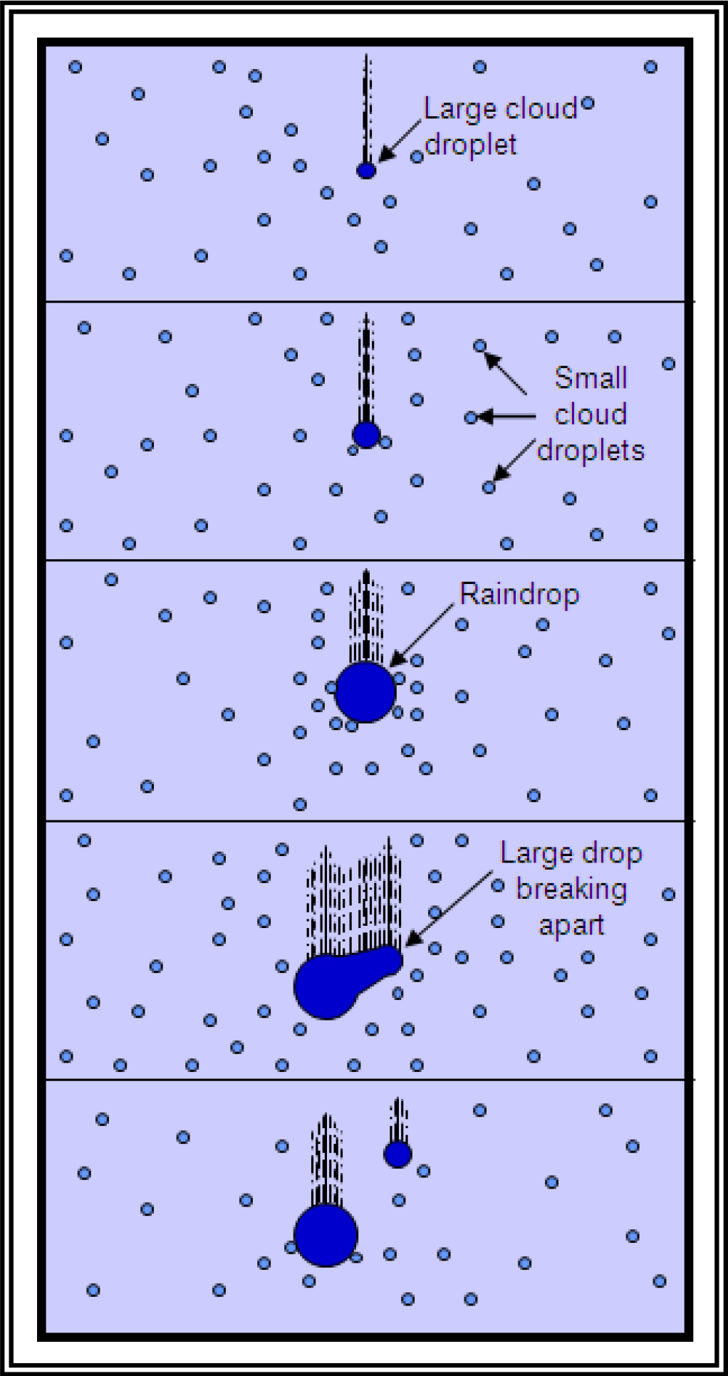
Figure 14-1. The collision-coalescence or warm rain process.
Most cloud droplets are too small and light to fall to the ground as precipitation. However, the larger cloud droplets fall more rapidly and are able to sweep up the smaller ones in their path and grow.
The other process is the ice crystal process. This occurs in colder clouds when both ice crystals and water droplets are present. In this situation, it is easier for water vapor to deposit directly onto the ice crystals so the ice crystals grow at the expense of the water droplets. The crystals eventually become heavy enough to fall. If it is cold near the surface, it may snow; otherwise, the snowflakes may melt to rain. This is thought to be the primary growth process in mid- and high-latitudes.
The vertical distribution of temperature will often determine the type of precipitation that occurs at the surface. Snow occurs when the temperature remains below freezing throughout the entire depth of the atmosphere (see Figure 14-2).
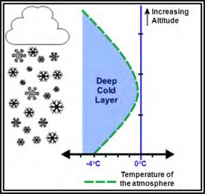
Figure 14-2. Snow temperature environment.
Ice pellets (sleet) occur when there is a shallow layer aloft with above freezing temperatures and with a deep layer of below freezing air based at the surface. As snow falls into the shallow warm layer, the snowflakes partially melt. As the precipitation reenters air that is below freezing, it refreezes into ice pellets (see Figure 14-3).
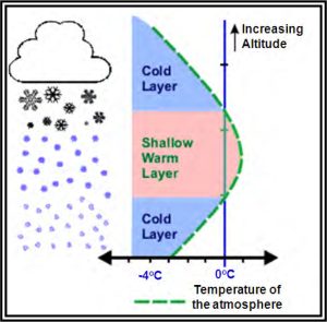
Figure 14-3. Ice pellets temperature environment.
Freezing rain occurs when there is a deep layer aloft with above freezing temperatures and with a shallow layer of below freezing air at the surface. It can begin as either rain and/or snow, but becomes all rain in the warm layer. The rain falls back into below freezing air, but since the depth is shallow, the rain does not have time to freeze into ice pellets (see Figure 14-4). The drops freeze on contact with the ground or exposed objects.
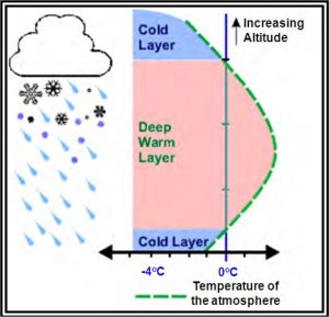
Figure 14-4. Freezing rain temperature environment.
Rain occurs when there is a deep layer of above freezing air based at the surface (see Figure 14-5).
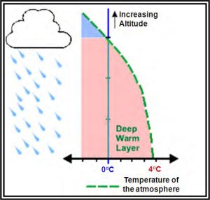
Figure 14-5. Rain temperature environment.