Local news in our area is reporting this morning of increased sightings of drones near SeaTac and PDX approaches. Incidents in the Pacific Northwest include a near-midair collision with a National Guard A-10 fighter based at Boise’s airport and a number of airline pilot reports of drone operations in the vicinity of airport operations including a “saucer-shaped UAS 100 feet below the aircraft’s left wing at 5,100 feet altitude in the Portland vicinity.” The FAA states that they receive more than 100 reports of unsafe drone activity each month nationwide and are suggesting that operators use the B4UFLY app to determine what restrictions or precautions they need to consider during their planned flight.
14 CFR §107.43, “Operation in the vicinity of airports,” is quite clear:
No person may operate a small unmanned aircraft in a manner that interferes with operations and traffic patterns at any airport, heliport, or seaplane base.
This, however, does not make operations near airports completely illegal. At SeaTac, for example, drone operations are prohibited in Class B Airspace unless prior approval is granted by FAA Air Traffic Control. 14 CFR §107.41, “Operation in certain airpsace,” clarifies this:
No person may operate a small unmanned aircraft in Class B, Class C, or Class D airspace or within the lateral boundaries of the surface area of Class E airspace designated for an airport unless that person has prior authorization from Air Traffic Control (ATC).
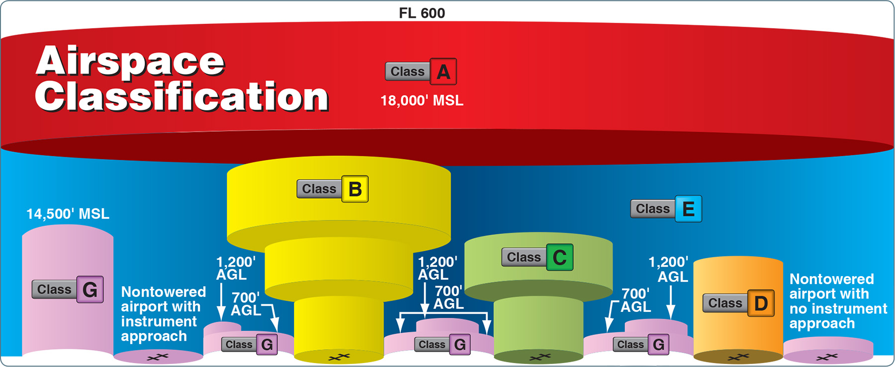
Controlled airspace is a generic term that covers the different classifications of airspace and defined dimensions within which air traffic control (ATC) service is provided in accordance with the airspace classification. Controlled airspace consists of Class A, Class B, Class C, Class D, and Class E airspace. Here’s how each is defined in the Pilot’s Handbook of Aeronautical Knowledge (8083-25).
Class A Airspace
Class A airspace is generally the airspace from 18,000 feet mean sea level (MSL) up to and including flight level (FL) 600, including the airspace overlying the waters within 12 nautical miles (NM) of the coast of the 48 contiguous states and Alaska. Unless otherwise authorized, all operation in Class A airspace is conducted under instrument flight rules (IFR).
Class B Airspace
Class B airspace is generally airspace from the surface to 10,000 feet MSL surrounding the nation’s busiest airports in terms of airport operations or passenger enplanements. The configuration of each Class B airspace area is individually tailored, consists of a surface area and two or more layers (some Class B airspace areas resemble upside-down wedding cakes), and is designed to contain all published instrument procedures once an aircraft enters the airspace. ATC clearance is required for all aircraft to operate in the area, and all aircraft that are so cleared receive separation services within the airspace.
Class C Airspace
Class C airspace is generally airspace from the surface to 4,000 feet above the airport elevation (charted in MSL) surrounding those airports that have an operational control tower, are serviced by a radar approach control, and have a certain number of IFR operations or passenger enplanements. Although the configuration of each Class C area is individually tailored, the airspace usually consists of a surface area with a five NM radius, an outer circle with a ten NM radius that extends from 1,200 feet to 4,000 feet above the airport elevation. Each aircraft must establish two-way radio communications with the ATC facility providing air traffic services prior to entering the airspace and thereafter must maintain those communications while within the airspace.
Class D Airspace
Class D airspace is generally airspace from the surface to 2,500 feet above the airport elevation (charted in MSL) surrounding those airports that have an operational control tower. The configuration of each Class D airspace area is individually tailored and, when instrument procedures are published, the airspace is normally designed to contain the procedures. Arrival extensions for instrument approach procedures (IAPs) may be Class D or Class E airspace. Unless otherwise authorized, each aircraft must establish two-way radio communications with the ATC facility providing air traffic services prior to entering the airspace and thereafter maintain those communications while in the airspace.
Class E Airspace
Class E airspace is the controlled airspace not classified as Class A, B, C, or D airspace. A large amount of the airspace over the United States is designated as Class E airspace.
This provides sufficient airspace for the safe control and separation of aircraft during IFR operations. Chapter 3 of the Aeronautical Information Manual (AIM) explains the various types of Class E airspace.
Sectional and other charts depict all locations of Class E airspace with bases below 14,500 feet MSL. In areas where charts do not depict a class E base, class E begins at 14,500 feet MSL.
In most areas, the Class E airspace base is 1,200 feet AGL. In many other areas, the Class E airspace base is either the surface or 700 feet AGL. Some Class E airspace begins at an MSL altitude depicted on the charts, instead of an AGL altitude.
Class E airspace typically extends up to, but not including, 18,000 feet MSL (the lower limit of Class A airspace). All airspace above FL 600 is Class E airspace.


