
Plotting a course? Today we’re learning about magnetic variation, with help from Bob Gardner’s The Complete Private Pilot textbook.
For flight planning purposes you must recognize that although the lines of latitude and longitude on charts are neatly perpendicular and relate to the True North Pole there is nothing in your airplane that relates to True North. The magnetic compass indicates the direction to the magnetic North Pole, which is in northern Canada (Figure 1).

You must take the variation between true north and magnetic north into account when flight planning.
Figure 2 shows isogonic lines, or lines of equal magnetic variation, across the continent. Along the line which passes through Chicago and Key West, a pilot looking toward the North Star or the True North Pole will also be looking toward the magnetic North Pole, and there will be no variation. The line of zero variation is called the agonic line. East or West of that line, the angle between true and magnetic north increases. A pilot in Los Angeles who measures a course line on an aeronautical chart in relation to the longitude lines (or true north) must subtract 14° from that true course to get a magnetic course (“East is least“), while a pilot in Philadelphia will add 10° (“West is best“). You will determine the true course by using your navigation plotter.
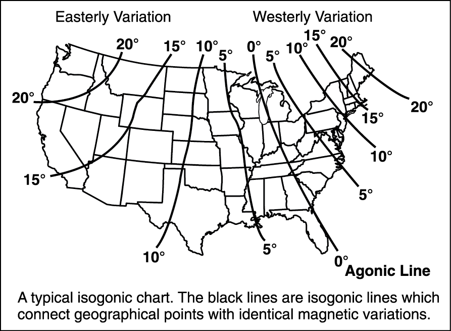
The variation on your sectional chart is almost certainly out-of-date. The isogonic lines on current sectionals were last updated in 2005 and will not be updated until 2011. Variations for navaids and airports are “assigned” and do not reflect the actual variation; variation for a VOR or airport can be up to three degrees different from actual variation is a current Airport/Facility Directory. You can get current variation information for airports along your route by going to http://www.ngdc.gov/geomagmodels/Declination.jsp.
Using the Navigation Plotter
A navigation plotter combines a protractor with mileage scales, and they are available in many forms. You use the protractor to measure the angle between a line of latitude or longitude and your course line. Refer to the Seattle sectional chart excerpt at the back of the book. Draw a line from the center of the airport symbol at Easton (A) to the center of the airport symbol at Wenatchee (H). Align the straight edge of your plotter with this course line and slide the plotter until the hole is over a vertical line of longitude; the angle should be approximately 78 degrees, indicating that the true course from Easton to Wenatchee is 078° and that the course for the return trip is 258°.
Deviation
A course, whether identified as true or magnetic, is only a line on a chart linking departure point and destination. For flight planning purposes, you must allow for magnetic influences in the airplane itself and for the effect of wind drift. Because your airplane has some iron and steel components which are affected by the earth’s magnetic field, and because it contains wiring which creates a magnetic field within the airplane itself, the airplane’s magnetic compass develops an error called deviation which varies with aircraft heading. Looking back at Figure 2, it is apparent that the heading of the airplane has nothing to do with magnetic variation — a pilot in Seattle must apply a 20° easterly variation regardless of the direction of flight. Because magnetic deviation is unique to each airplane and is dependent on heading, a compass correction card (Figure 3) must be prepared by accurately lining up the airplane on known magnetic headings, checking the magnetic compass reading, and recording the deviation error for each heading. Small adjustment magnets are provided so that the error can be minimized.
This compass correction table is originally made at the factory but should be re-checked by a mechanic whenever cockpit equipment installations are made. When a pilot has applied variation and deviation to a measured true course, the result is the compass course:
True ± Variation = Magnetic ± Deviation = Compass
Variation is shown on navigational charts to the nearest one-half degree. You will find that rounding off to the nearest whole degree will speed up your calculations without affecting accuracy. If you make long flights over water or featureless terrain, deviation and compass course will be very important to you, and an accurate compass correction card may be a lifesaver. Pilots who fly by reference to the surface (pilotage) will make little use of compass heading except to adjust their gyroscopic heading indicators.
Any difference between an airplane’s planned course and its track over the ground is caused by wind drift. Always compute the wind correction angle first, and then apply variation and deviation, as National Weather Service winds aloft forecasts are always referenced to True North.


