Just the other day I was on a commercial airline flight on my way home from vacation. Prior to departure, the captain came on the overhead to advise the passengers that we would be arriving about 15 minutes late due to headwinds along the route. Like the captain did, it is an important part of your cross country flight planning to check the forecasted winds, known as the Winds and Temperatures Aloft Forecast (FB). Understanding what the winds are doing aloft will allow you to estimate several different factors, including your time en-route, approximate time of arrival, fuel burn, and compass headings.
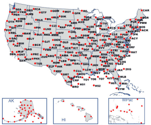
The FB is issued 4 times daily for specified locations across the U.S and coastal waters as seen in the figure below.

It can get a little tricky understanding how to interpret the textual forecast. First, it’s important to understand that the winds are given in degrees true and that winds are specified in knots. The information is formatted like so DDffTT, Wind Direction (DD), Wind Speed (ff), and Temperature (TT). Using the forecast from below let’s look at DEN (Denver) at 9,000 feet MSL, 2321-04. The first two numbers 23 represent the direction of the wind in degree true, 230 (you will need to add on a 0). Next, the 21 represents the wind speed, in this case 21 knots. Finally, the temperate is shown as -04 or negative 4 degrees Celsius. You will either see a + or – displayed with the temperature to indicate positive or negative, above 24,000 feet no + or – sign is noted as all temperatures will be negative.
So far pretty simple, but it can get a bit trickier. Anytime the wind is in excess of 99 knots 50 will be added to the coded wind direction and 100 subtracted from the coded wind. A code indicating 7760-20 would decode as 270 degrees true at 160 knots and a temperature of negative 20 degree Celsius. Take the first two numbers 77 (our wind direction) and subtract 50 to get 27. Next take 60 (wind speed) and add on 100 to get 160. Lets try one more, 8242-15 decodes as 320 @ 142 knots and a temperature of negative 15. Subtract the 50 from 82 and then add on 100 to 42.
Now if you take another look at our example forecast below you will notice that no information is given for AMA at 3,000 feet MSL. This is due to the altitude at which the station is located. Wind forecasts are not issued for altitudes within 1,500 of the locations elevation and temperatures within 2,500 feet. Something else to take note of is anytime winds are light and variable or less than 5 knots it will be express as 9900. Try your hand at the three sample questions below, you can use figure 17 included here to answer each questions. The questions are similar in nature to what may appear on your Private Pilot Knowledge Exam.

1. (Refer to Figure 17.) What wind is forecast for STL at 9,000 feet?
A—230° true at 32 knots.
B—230° magnetic at 25 knots.
C—230° true at 25 knots.
2. (Refer to Figure 17.) What wind is forecast for STL at 12,000 feet?
A—230° true at 56 knots.
B—230° magnetic at 56 knots.
C—230° true at 39 knots.
3. (Refer to Figure 17.) What wind is forecast for STL at 12,000 feet?
A—230° true at 56 knots.
B—230° magnetic at 56 knots.
C—230° true at 39 knots.


