Monday’s post introduced us into the subject of aircraft performance, focusing on how the environment we fly in, specifically the atmosphere and altitude, can affect the overall performance of the aircraft. Two very important altitudes were discussed; Pressure Altitude and Density Altitude both of which are significant when determining aircraft performance. Be particularly aware when your conditions are hot, high or heavy—all indications your density altitude is going to negatively impact your aircraft performance. If you take away one thing from that post remember this: Higher Density Altitude = Decreased Performance.
Understanding the effects of density altitude is one thing but knowing how to determine the density altitude at any given point is another, so today let’s cover how to determine your density altitude. The first step is obtaining the airport data and current weather information. For this example we will use Big Bear City Airport (L35). Using the AF/D I determined an airport elevation of 6,752 feet. This piece of information alone should start to raise some concerns regarding aircraft performance—this is pretty high. Next I will need the current METAR (assuming it’s a nice summer day in August):
METAR KL35 102055Z AUTO 00000KT 10SM CLR 25/01 A3025 RMK AO2
Airport Elevation: 6,752
With the given information above we can determine the density altitude with our CX-2 flight computer, as the video below will demonstrate.
The current density altitude at Big Bear is 9,019; this is more than 2,200 feet above the already high airport elevation.
Try a few calculations on your own and see how you do, these are questions you will likely see on your Private Pilot FAA Knowledge Exam. Answers posted on Monday.
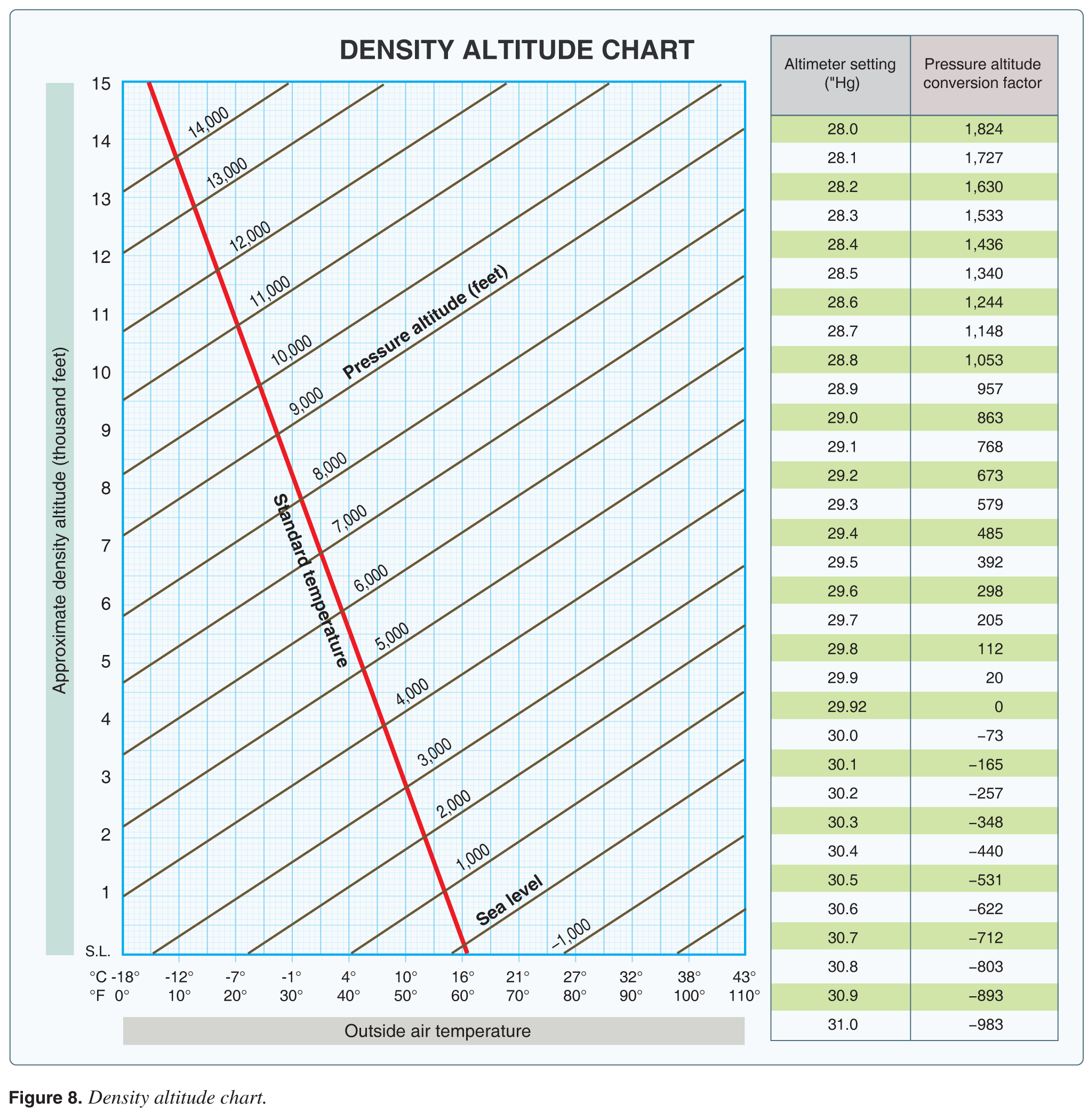
1. (Refer to Figure 8.) What is the effect of a temperature increase from 25 to 50°F on the density altitude if the pressure altitude remains at 5,000 feet?
A—1,200-foot increase.
B—1,400-foot increase.
C—1,650-foot increase.
2. (Refer to Figure 8.) Determine the density altitude for these conditions:
Altimeter setting: 29.25
Runway temperature: + 81°F
Airport elevation: 5,250 ft MSL
A—4,600 feet MSL.
B—5,877 feet MSL.
C—8,500 feet MSL.
3. (Refer to Figure 8.) Determine the density altitude for these conditions:
Altimeter setting: 30.35
Runway temperature: +25°F
Airport elevation: 3,894 ft MSL
A—2,000 feet MSL.
B—2,900 feet MSL.
C—3,500 feet MSL.